

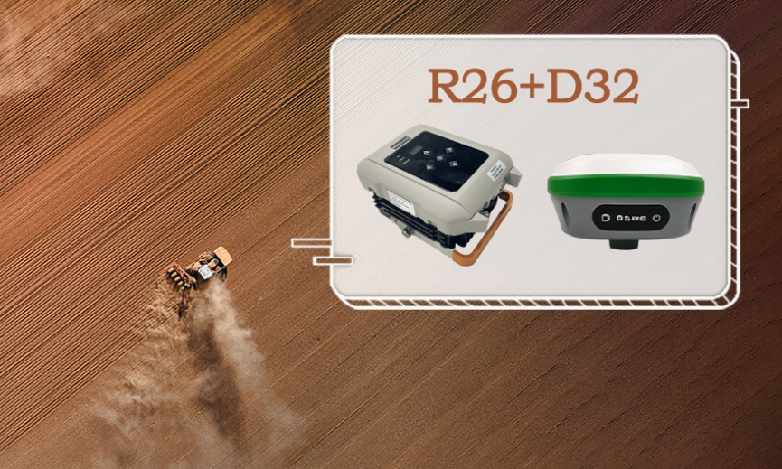
At the forefront of innovation stands the R26 Surveying Base, a pinnacle of state-of-the-art engineering. Developed by SMAJAYU, this equipment embodies excellence with its integrated Beidou/GNSS receiver, large-capacity battery, and memory card. Leveraging multi-functional high-precision inertial navigation RTK technology, the R26 ensures unparalleled accuracy in positioning and orientation. Its full-frequency antenna and advanced modules, including Bluetooth and radio capabilities, cement its status as a versatile powerhouse catering to the diverse needs of modern surveyors.
Unlocking the Potential of GPS Surveying: The Evolution of Precision
The surveying and mapping industry is undergoing a profound transformation, driven by the relentless pursuit of precision and efficiency. Traditional methods are giving way to high-precision solutions, fueled by the demand for real-time kinematic (RTK) capabilities. This shift underscores the industry’s quest for unparalleled accuracy and reliability in every aspect of surveying operations.
1.2 Embracing Innovation: The Imperative for Cutting-Edge Equipment
In this dynamic landscape, the need for cutting-edge equipment has never been more pronounced. Surveyors are in search of solutions that not only meet but exceed industry standards, empowering them to tackle the complexities of modern surveying challenges. Enter the R26 Surveying Base and D32 Radio Station – a transformative duo poised to revolutionize surveying operations and elevate industry benchmarks.
1.3 Understanding the R26: A Closer Look at its Key Features
1. Integrated Beidou/GNSS Receiver: Seamlessly integrates Beidou/GNSS technology for enhanced precision and reliability.
2. High-Capacity Battery and Memory Card: Ensures uninterrupted operation and ample storage for extensive data collection.
3. Multi-Functional Inertial Navigation RTK Technology: Delivers precise positioning and orientation, even in challenging environments.
4. Full-Frequency Antenna and Advanced Modules: Facilitates seamless communication and connectivity, optimizing workflow efficiency.
Exploring the D32 Radio Station: Enhancing Connectivity and Collaboration
Complementing the R26 is the D32 Radio Station, designed to elevate connectivity and communication in surveying and mapping environments. Engineered for high-power transmission, this digital radio station is tailored to meet the rigorous demands of precision agriculture applications. Its single-transmission capabilities empower surveyors to seamlessly transfer data and collaborate across diverse terrain and environmental conditions.
2.1 Unveiling the D32: A Deeper Dive into its Benefits
1. High-Power Transmission: Enables reliable data transfer over long distances, ensuring uninterrupted communication.
2. Precision Agriculture Compatibility: Tailored to meet the unique needs of precision agriculture applications, enhancing productivity and efficiency.
3. Seamless Data Transfer: Facilitates smooth collaboration among surveying teams, fostering synergy and productivity.
2.2 SMAJAYU: Pioneering Innovation in GPS Surveying
At the heart of these groundbreaking solutions lies SMAJAYU, a trailblazer in the field of GPS surveying technology. With a relentless commitment to innovation and excellence, SMAJAYU continues to push the boundaries of possibility, empowering surveyors worldwide to achieve new heights of precision and efficiency.
3.1 Mastering the Art of GPS Surveying: Techniques and Best Practices
GPS surveying has become an indispensable tool for professionals across various industries, from land surveyors and construction engineers to environmental scientists and urban planners. However, achieving accurate results and maximizing efficiency in GPS surveying requires more than just access to the right equipment. Here, we delve into the essential techniques and best practices to help you master the art of GPS surveying.
3.2 Understanding GPS Surveying: The Basics
At its core, GPS surveying utilizes signals from satellites orbiting the Earth to determine precise locations on the planet’s surface. By triangulating signals from multiple satellites, GPS receivers can calculate accurate coordinates for any given point. Understanding the basics of GPS technology is essential for conducting successful surveys and interpreting the data collected.
3.3 Key Concepts in GPS Surveying
1. Satellite Geometry: Learn how the arrangement of satellites in the sky affects the accuracy of GPS measurements, and how to optimize satellite geometry for better results.
2. Error Sources: Familiarize yourself with common sources of error in GPS surveying, such as atmospheric interference, multipath effects, and satellite clock errors, and learn how to mitigate them.
3. Data Processing: Explore different methods for processing GPS data, including real-time kinematic (RTK) correction, post-processing, and differential GPS (DGPS), to improve accuracy and reliability.
Choosing the Right GPS Survey Equipment: Tips and Considerations
Selecting the right GPS survey equipment is crucial for achieving accurate results and maximizing efficiency in the field. With a wide range of options available on the market, it’s important to consider factors such as accuracy requirements, environmental conditions, and budget constraints. Here are some key tips to help you choose the perfect GPS surveying gear for your needs.
1. Accuracy Requirements: Determine the level of precision needed for your surveys and select equipment that meets or exceeds those requirements.
2. Environmental Considerations: Consider the terrain, weather conditions, and potential obstacles in your survey area, and choose equipment that can withstand and perform optimally in such conditions.
3. Compatibility and Integration: Ensure compatibility between different components of your surveying equipment, such as GPS receivers, antennas, and data collectors, to streamline workflow and data management processes.
Why Choose SMAJAYU for Your GPS Surveying Needs?
In the competitive landscape of GPS surveying equipment manufacturers, SMAJAYU stands out as a leader in innovation, reliability, and customer satisfaction. With a track record of delivering cutting-edge solutions tailored to the unique needs of surveyors worldwide, here’s why SMAJAYU should be your top choice for GPS surveying equipment.
1. Innovative Technology: Explore the latest advancements in GPS surveying technology, including integrated Beidou/GNSS receivers, high-precision inertial navigation RTK technology, and advanced communication modules.
2. Reliability and Durability: Count on SMAJAYU equipment to perform reliably in the most challenging environments, thanks to robust construction, weatherproof design, and rigorous quality control standards.
3. Customization and Flexibility: Tailor your GPS surveying setup to your specific requirements with customizable options and flexible configurations, ensuring maximum versatility and efficiency in the field.
4. Exceptional Support and Service: Benefit from SMAJAYU’s commitment to customer satisfaction, with comprehensive technical support, training programs, and warranty coverage to keep your equipment running smoothly.

Conclusion: Elevating Surveying Operations with Cutting-Edge Technology
As the surveying and mapping industry continues to evolve, embracing advanced technologies is not just a choice but a necessity. The R26 Surveying Base and D32 Radio Station represent the vanguard of this technological revolution, offering unparalleled precision, versatility, and reliability. With SMAJAYU leading the charge, the future of GPS surveying has never looked brighter.
