

In the realm of surveying, where accuracy and efficiency are paramount, professionals constantly seek out cutting-edge tools to elevate their performance and enhance their capabilities. The critical question arises: how can one achieve impeccable precision while simultaneously maintaining rapid execution and unwavering reliability? The solution lies in making a strategic choice of equipment, and the R26 Surveying System emerges as a standout contender. Engineered to deliver unparalleled precision, robust durability, and exceptional versatility, this GNSS surveying system is reshaping how industry experts approach their tasks. Through this article, we will delve into the reasons why the R26 Surveying System proves to be the ideal choice for professionals intent on optimizing their surveying potential.
Why the R26 Surveying System Is the Definitive Tool for Surveying Experts
Surveying is a discipline where even the slightest deviation in accuracy can dictate the success or failure of an entire project. The R26 Surveying System, a product of SMAJAYU, integrates cutting-edge technology to ensure that every measurement is executed with the highest level of precision. What exactly makes this system the premier tool for surveyors?
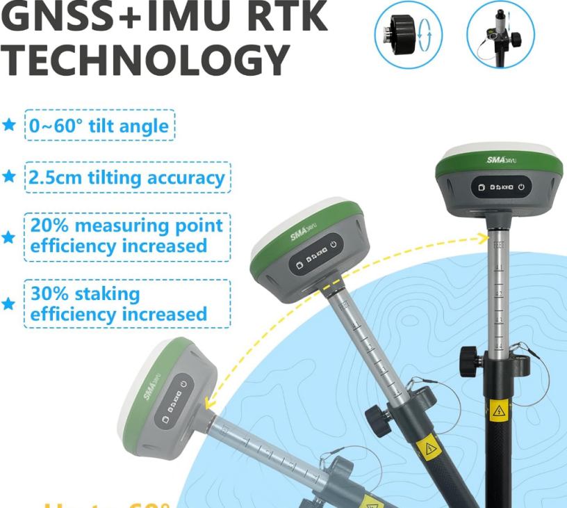
Built for Unrivaled Precision with GNSS and IMU Integration
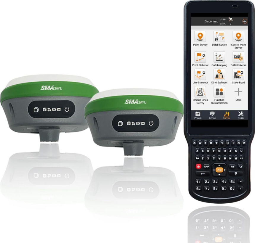
At the heart of the R26 Surveying System lies its GNSS receiver, which is augmented by IMU (Inertial Measurement Unit) technology. The system comprises both a SMA26 rover and a base station, each furnished with precision-engineered positioning boards and GNSS full-frequency antennas. This robust combination empowers surveyors to capture real-time data with a degree of accuracy that few other systems can match. By leveraging RTK (Real-Time Kinematic) technology, the system further enhances this capability by facilitating dynamic, on-the-fly corrections to measurements, ensuring that immediate feedback is available and no critical detail is overlooked.
The R26 GNSS system is based on NebulasIV technology and supports 1408 channels. Signal integrity is maintained even in the most demanding environments. This level of accuracy is essential for large-scale projects, including land development, infrastructure construction, and utility mapping. Because accuracy determines the success of a project.
Extended Battery Life for Prolonged Operation in the Field
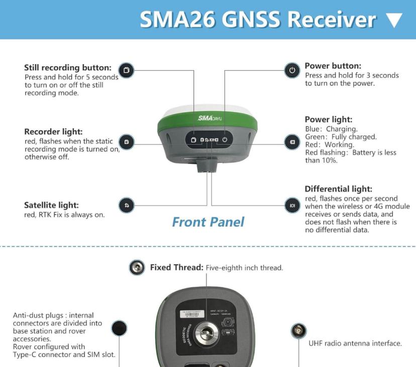
A notable attribute of the R26 Surveying System is its built-in battery, which features a remarkable capacity of 10200mAh. This allows the system to function continuously for more than 14 hours without requiring a recharge. For professionals operating in remote or inaccessible areas, where charging facilities are scarce or non-existent, this extensive battery life is vital for ensuring uninterrupted productivity and efficient project progression.
Designed with a rugged, durable framework, the R26 system is engineered to endure the harshest outdoor environments. Be it extreme heat, torrential rain, or challenging terrains, the R26 is built to endure and thrive under difficult conditions, making it the go-to option for surveyors who demand reliability in any setting.
Enhanced Communication Flexibility with Integrated UHF Wireless
Equipped with a built-in UHF (Ultra High Frequency) wireless module, the R26 Surveying System enables smooth and efficient communication between the rover and the base station. This wireless transceiver is designed to automatically switch between mobile station and base station modes, facilitating uninterrupted data transmission throughout surveying operations. Moreover, the system’s CSS (Lora) protocol further amplifies its wireless capabilities, ensuring stable and reliable connections across vast distances, even in the most challenging environments.
The flexibility of the communication system allows surveyors to adjust seamlessly to suit different project requirements. No need to worry about data transmission interruption or signal loss. For large projects covering large areas, the ability to maintain reliable and consistent communication between the rover and the base station is critical to achieving high-speed data collection and maintaining accuracy.
From Field to Finish: Enhancing Efficiency with the R26 Surveying System
In the ever-evolving world of modern surveying, where the scale and complexity of projects continue to expand, achieving efficiency becomes a pivotal factor. Surveying professionals are in constant search of instruments that not only simplify workflow management but also maintain the utmost accuracy. In this regard, the R26 Surveying System proves to be exceptional, as it ensures that each phase of the surveying process is executed with the highest level of efficiency, from initial data collection to project completion.
Rapid and Dependable Data Collection
The R26 system is able to collect and process data quickly. This is due to its sophisticated integration of RTK (Real Time Kinematic) technology and IMU (Inertial Measurement Unit). This cutting-edge combination enables surveyors to acquire data in real time, greatly reducing the need for subsequent post-processing. And shortening field work time. In addition, with the system’s 4G connection and powerful data transmission capabilities. All collected data can be immediately transmitted to the office for further analysis. This seamless and immediate data transfer accelerates the overall project timeline, facilitating faster decision-making and keeping projects on track.
By simplifying the time-consuming data collection and transfer process. The R26 system ensures even the most time-sensitive projects are executed faster. All while maintaining impressive accuracy and precision.
Intuitive Design Paired with User-Friendly Software
One of the standout benefits of the R26 Surveying System lies in its intelligently designed, easy-to-navigate software. The system is equipped with an intuitive user interface that simplifies the learning process. This allows surveyors to quickly master the system’s functionality and begin using it effectively with minimal training. This ease of use enables professionals to configure systems, collect basic data and manage projects. Without unnecessary delays caused by complex technology.
This focus on user-friendliness not only improves operational efficiency but also minimizes the learning curve for new users, enabling teams to focus their energy on delivering results rather than grappling with complicated equipment.
Built to Endure Challenging Conditions
Surveying professionals are frequently tasked with working in extreme environments, where the demands placed on their equipment are formidable. The R26 system is designed with durability in mind. Ensuring it can withstand the toughest outdoor conditions. The unit is ruggedly constructed to operate seamlessly in a variety of environmental challenges. Including scorching heat, heavy rain, and rugged terrain.
This resilience not only protects the financial investment in the equipment. It also improves overall efficiency by reducing the risk of equipment failure, which could otherwise cause project delays or costly downtime. As a result, the R26 system proves to be a reliable partner for professionals working in a variety of demanding environments. It ensures smooth operations regardless of external conditions.
R26 Surveying System Review: Accuracy, Reliability, and Speed Combined
When investing in a surveying system, accuracy, reliability, and speed are the top priorities. The R26 Surveying System excels in all three areas, making it a top choice for professionals who need to deliver precise results on time.
Pinpoint Accuracy with RTK GNSS Receiver
Accuracy is one of the biggest strengths of the R26 system. Its double SMA26 RTK GNSS receiver ensures that measurements are incredibly precise, reducing the margin of error to nearly zero. This accuracy is essential for projects that require exact measurements, such as construction site planning or boundary mapping.
Reliability You Can Count On
The R26 system’s design ensures it delivers consistent performance, even in challenging conditions. Its long battery life, robust signal tracking, and built-in wireless communication modules guarantee that surveyors can rely on the system for long, uninterrupted operation. This reliability means fewer disruptions in the field and more accurate results.
Speed to Keep Projects on Track
In addition to its accuracy and reliability, the R26 system is designed for speed. By leveraging real-time data processing and rapid data transfer capabilities, surveyors can work faster without sacrificing quality. This is crucial in large projects where time is of the essence and delays can lead to increased costs.
How to Improve Data Collection with the R26 Surveying System
Data collection is a core part of surveying, and the R26 Surveying System makes it easier and more efficient than ever before. Here’s how it can improve your data collection process.
Advanced GNSS Technology for Faster Data
With the integration of RTK and GNSS technology, the R26 system allows for rapid and accurate data collection. Whether you’re mapping complex terrains or collecting data in urban environments, the R26’s 1408 channels ensure that signals are tracked consistently, even in difficult conditions.
Continuous Operation for Large Projects
The R26 system’s long battery life means that data collection can continue uninterrupted for over 14 hours. For large-scale projects, this is invaluable. Surveyors can cover more ground without having to stop and recharge, increasing the efficiency of data collection.
Seamless Data Transfer for Quick Analysis
Data collected by the R26 Surveying System can be quickly transferred to the office via 4G or wireless protocols. This reduces the time between data collection and analysis, enabling project managers to make faster decisions and keep the project on track.
Conclusion: Why Choose the R26 Surveying System?
In the world of surveying, precision, efficiency, and reliability are paramount. The R26 Surveying System from SMAJAYU offers all three in a single, comprehensive package. With its advanced GNSS technology, durable design and user-friendly software. It’s the ultimate tool for professionals looking to improve their measurement skills. Whether you are working on a large construction project or detailed boundary mapping. Both R26 systems help you deliver results accurately and quickly.
