

The agricultural industry has witnessed a significant transformation over the past few decades, driven by advancements in technology. One such innovation that has revolutionized precision farming is the integration of GPS Real-Time Kinematic (RTK) systems. These high-precision and affordable GNSS (Global Navigation Satellite System) solutions have not only enhanced accuracy but also made precision farming accessible to farms of all sizes. Among the leading suppliers in this field, SMAJAYU has emerged as a prominent player, providing cutting-edge agriculture guidance and auto-steer solutions with centimeter-level precision.
I. The Industry Status and Growing Trends in RTK GNSS Technology:
1. Increasing Demand for Precision Farming:
As farmers strive to maximize their yields, minimize resource wastage, and optimize crop quality, the demand for precision farming technologies has been on the rise. RTK GNSS systems have played a crucial role in meeting these requirements, enabling farmers to achieve sub-inch accuracy in various agricultural operations.
2. Accessibility for All-Size Farms:
Historically, high-precision farming technologies were often limited to large-scale operations due to their high costs. However, the advent of affordable RTK GNSS solutions has democratized precision farming, allowing small and medium-sized farms to reap the benefits of accurate positioning and guidance systems.
3. Enhanced Efficiency and Cost Savings:
By integrating GPS accuracy technology, RTK GNSS systems streamline farming processes, enabling precise field mapping, seeding, spraying, and harvesting. With centimeter-level accuracy, farmers can minimize overlap and reduce input costs, ultimately improving operational efficiency and increasing profitability.
II. SMAJAYU: Pioneering RTK GNSS Solutions for Precision Agriculture:
1. Cutting-Edge Technology Offerings:
SMAJAYU has positioned itself as a leading supplier of high-precision RTK GNSS systems tailored specifically for the agricultural sector. Their state-of-the-art solutions integrate advanced GPS technology with robust agriculture guidance and auto-steer functionalities. With SMAJAYU’s offerings, farmers can achieve unparalleled accuracy and efficiency in their day-to-day operations.
2. Centimeter-Level Precision Farming:
SMAJAYU’s RTK GNSS systems provide centimeter-level accuracy, allowing farmers to precisely navigate their equipment across fields. This level of precision ensures optimal seed placement, uniform coverage of fertilizers and pesticides, and accurate steering during harvesting. By minimizing errors and optimizing inputs, farmers can maximize yields and reduce waste.
3. User-Friendly Interface and Adaptability:
SMAJAYU understands the importance of user experience in technology adoption. Their systems feature intuitive interfaces that are easy to navigate, enabling farmers to quickly integrate and utilize the RTK GNSS technology. Furthermore, SMAJAYU’s solutions are adaptable to a wide range of farming equipment, making them suitable for various agricultural practices and machinery.
III. The Future of RTK GNSS in Precision Farming:
1. Continued Advancements and Integration:
As technology continues to evolve, RTK GNSS systems are expected to undergo further enhancements. Integration with other cutting-edge technologies, such as artificial intelligence and machine learning, is likely to unlock even greater potential for precision farming. SMAJAYU and other industry players are actively exploring these avenues to drive innovation in the sector.
2. Increasing Adoption and Industry Collaboration:
The affordability and accessibility of RTK GNSS systems have resulted in a surge in their adoption across the agricultural landscape. As more farmers experience the benefits of precision farming, industry-wide collaboration and knowledge sharing are expected to flourish. This collective effort will fuel the development of new applications and best practices, further propelling the industry forward.
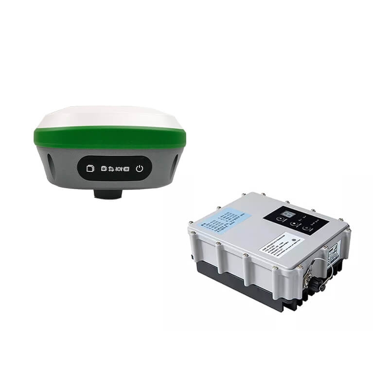
Ⅳ. GPS RTK: 10-20km RTK Radio Station and R26 Surveying Base for Sale
When it comes to precision and accuracy in surveying and engineering, having reliable GPS technology is crucial. SMAJAYU, a leading supplier in the industry, offers an exceptional solution with their 10-20km RTK Radio Station and R26 Surveying Base. These cutting-edge devices have gained popularity among professionals, earning a stellar reputation and 100% recommendation rate.
1. R26 Surveying Base:
The R26 is an integrated Beidou/GNSS receiver with a wide range of advanced features. It is equipped with a built-in large-capacity battery and memory card, ensuring extended operation and data storage capabilities. The R26’s high-precision inertial navigation RTK receiver, developed independently by SMAJAYU, guarantees accurate positioning and orientation. The device also incorporates a Beidou/GNSS full-frequency antenna, Bluetooth connectivity, and radio modules, providing seamless integration with other equipment.
2. D30 Radio Station:
The D30 Radio Station supports protocols such as SOUTH/TRIMTALK/TRANSEOT(PCC), making it compatible with a variety of precision agriculture, surveying, geographic information, and Drone RTK communication applications. With a signal range of 20km, it offers an extensive coverage area, enabling effective communication and data exchange between devices.
Ⅴ. Benefits of the R26 and D30 Combination:
1. Enhanced Precision: The R26 Surveying Base, combined with the D30 Radio Station, delivers highly accurate and reliable results, ensuring the success of surveying and engineering projects.
2. Versatility: The R26 and D30 combination supports various applications, including precision agriculture, surveying, geographic information systems, and Drone RTK communication.
3. Extended Signal Range: With a remarkable 20km signal range, the D30 Radio Station provides excellent coverage, minimizing signal loss and ensuring seamless communication in large-scale projects.
4. Efficient Data Management: The R26’s large-capacity memory card allows for extensive data storage, eliminating the need for frequent transfers and enhancing workflow efficiency.
Ⅵ. Applications of the R26 and D30 Combination:
1. Agricultural Systems: The R26 and D30 combination is an ideal choice for precision agriculture, facilitating intelligent spray systems, leveling systems, and guidance systems (such as the JY100 Guidance System). This integration enables accurate data collection and efficient utilization of resources.
2. Surveying & Engineering: With its high-precision positioning capabilities, the R26 Surveying Base excels in RTK surveying and engineering projects. It seamlessly integrates with the JY305 AutoSteering System, offering precise guidance and navigation for various applications.
3. GNSS RTK: The R26 and D30 combination empowers professionals in the field of GNSS RTK surveying, ensuring accurate measurements and precise positioning.
Conclusion:
GPS RTK technology has brought about a paradigm shift in precision farming, empowering farmers to achieve unparalleled accuracy and efficiency in their operations. SMAJAYU, a leading supplier of RTK GNSS systems, has played a pivotal role in this transformation by providing affordable and user-friendly solutions with centimeter-level precision. As the industry continues to evolve, the integration of RTK GNSS with emerging technologies promises to unlock even greater potential, paving the way for a more sustainable and productive agricultural future.
