

In the realm of topography surveying, SMAJAYU has emerged as a distinguished name, backed by over a decade of expertise and an unwavering commitment to innovation. Since its inception in 2009, SMAJAYU has traversed the dynamic landscape of technology, evolving from traditional surveying devices to cutting-edge smart equipment. With a firm foundation in precision mapping, SMAJAYU has embraced a new mission – supporting the development of agriculture through intelligent solutions. Our high-precision and cost-effective RTK GNSS system has revolutionized farming technology adoption, benefitting farms of all sizes. By seamlessly integrating GPS accuracy technology, SMAJAYU’s agriculture guidance and auto-steer systems ensure centimeter-level precision in farming practices.
The Evolution of Topography Survey Equipment
Historical Perspective on Traditional Surveying Tools
Surveying has a rich history rooted in the use of manual instruments, such as theodolites, chains, and levels. These tools, while fundamental, were limited in their precision and efficiency, often requiring labor-intensive efforts to map terrain accurately.
Modern Technology and Impact on Survey Equipment
The advent of modern technology marked a seismic shift in the surveying landscape. Global Navigation Satellite Systems (GNSS), like GPS, revolutionized the field by offering unprecedented accuracy and real-time data collection capabilities. Survey equipment became more sophisticated, compact, and user-friendly, enabling surveyors to achieve centimeter-level precision efficiently.
SMAJAYU’s Role in Adopting Cutting-Edge Advancements
SMAJAYU has been at the forefront of embracing these technological advancements. Our commitment to providing high-precision and affordable RTK GNSS systems has reshaped industries, especially agriculture. By integrating GNSS technology and offering centimeter-level positioning accuracy, SMAJAYU empowers precision farming, optimizing resource use and crop yields.
As we transition from traditional surveying tools to state-of-the-art equipment, SMAJAYU’s dedication to innovation ensures that precision mapping reaches new heights, benefiting a wide range of sectors, from agriculture to construction and beyond. Our GNSS global corrections service, delivered via satellite and the internet, underscores our commitment to centimeter-level positioning accuracy, driving progress in precision mapping.
SMAJAYU’s Topography Survey Equipment
Overview of the Range of Survey Equipment Offered
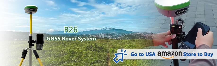
SMAJAYU’s topography survey equipment is designed to meet the diverse needs of professionals in precision mapping. Our flagship offering, the R26 Surveying System Rover+Base, is a testament to technological excellence. It boasts:
- Supporting Multi-Satellite System Full-Band Satellite Signal Reception: This feature ensures that our equipment can receive signals from multiple satellite systems, guaranteeing robust and reliable data acquisition in even the most challenging environments.
- Higher Accuracy and Precision: SMAJAYU’s surveying equipment is renowned for its exceptional accuracy, delivering centimeter-level precision. This level of precision is essential in various industries and applications.
- Engineered for Field Use: Our surveying solutions are thoughtfully engineered to excel in real-world field conditions. Whether it’s rugged terrain or adverse weather, our equipment and expertise are geared to deliver precise results.
Key Features and Benefits
The R26 integrated Beidou/GNSS receiver, a pivotal component of our equipment, offers a remarkable set of features, including:
- A built-in large-capacity battery for extended operation in the field.
- Extensive memory card storage to accommodate vast datasets.
- Integration of multi-functional high-precision technology, ensuring accurate positioning.
Equipment’s Role in Accurate Terrain Assessment
SMAJAYU’s topography survey equipment plays a pivotal role in achieving accurate terrain assessment. The equipment’s ability to receive multi-satellite signals, coupled with its high precision and rugged design, ensures that it can capture precise elevation and topographic data, facilitating informed decision-making in various industries. Whether it’s for construction, agriculture, or environmental conservation, our equipment stands as a reliable ally in the pursuit of precise terrain assessment.
Advanced Technology Integration
Advanced Technologies Incorporated in SMAJAYU’s Equipment
SMAJAYU’s commitment to cutting-edge technology is exemplified by our R26 Surveying System, which integrates a host of advanced components:
- Inertial Navigation RTK Receiver: Developed independently by SMAJAYU, this technology provides real-time kinematic (RTK) positioning and navigation, ensuring accuracy even in dynamic environments.
- Built-in Beidou/GNSS Full-Frequency Antenna: This antenna receives signals from multiple satellite systems, offering comprehensive coverage for precise positioning.
- Multiple Frequency Points: The system utilizes various frequency points to enhance accuracy and reliability.
- High-Precision Positioning and Orientation Boards: These boards contribute to precise data collection and orientation.
- Bluetooth Connectivity: Enables seamless communication and data transfer between surveying equipment and other devices.
- Inertial Navigation: Augments positioning accuracy by accounting for motion and changes in direction.
- Radio Modules: Facilitate communication between base and rover stations, ensuring data synchronization.
SMAJAYU’s equipment leverages GNSS technology, which encompasses satellite systems like GPS, Glonass, BeiDou, Galileo, and QZSS. These systems provide a constellation of satellites that transmit signals to Earth. GNSS allows for precise positioning and navigation by triangulating signals from multiple satellites, even in challenging conditions. This integration of multiple satellite systems significantly enhances precision, making it a vital component in our surveying equipment.
High-gain antennas are instrumental in improving the efficiency of GNSS satellite signal tracking. They increase signal reception sensitivity, resulting in faster, more accurate positioning. Inertial navigation complements this by accounting for changes in direction and motion, ensuring that the equipment provides accurate data even in dynamic situations. These technologies collectively contribute to the exceptional precision and reliability of SMAJAYU’s topography survey equipment, making it the ideal choice for various industries and applications.
Real-world Applications
SMAJAYU’s topography survey equipment finds invaluable applications across a spectrum of industries and projects. It plays a pivotal role in:
- Construction and Engineering: Guiding the design and construction of infrastructure projects with precise terrain mapping.
- Agriculture: Optimizing resource allocation and crop management through centimeter-level precision, boosting yields and conservation efforts.
- Environmental Conservation: Monitoring and preserving ecosystems, tracking landform changes, and enabling informed conservation strategies.
- Forestry Management: Supporting sustainable logging practices, forest inventory management, and wildlife habitat preservation.
- Mining and Minerals: Enhancing mining operations by aiding excavation, waste management, and environmental impact assessment.
- Land Development: Assessing land suitability for real estate development, subdivision planning, and zoning compliance.
- Floodplain Management: Modeling flood risk, managing floodplains, and implementing flood control measures with accurate elevation data.
SMAJAYU’s equipment empowers precision mapping, making it an indispensable tool across diverse sectors, facilitating informed decision-making and sustainable development.
Expertise and Support
SMAJAYU’s Experienced Team and Customer Support
24 Hours Online Support: Our dedicated team is available round the clock to assist and address any queries or concerns.
1-Year Warranty: SMAJAYU stands by the quality of its equipment, offering a 1-year warranty to ensure peace of mind for our clients.
How SMAJAYU Assists Clients in Maximizing the Potential of Their Equipment
SMAJAYU goes beyond providing topography survey equipment. We partner with clients, offering guidance and expertise to help them harness the full potential of our technology. Our team collaborates with users to ensure seamless integration, efficient operation, and effective data utilization, empowering clients to achieve their goals with precision and confidence.
The Future of Topography Survey Equipment
Upcoming Trends and Innovations in the Field
As we look ahead, the future of topography survey equipment promises exciting advancements. Anticipate developments such as enhanced real-time data processing, increased automation, and the incorporation of artificial intelligence to revolutionize data analysis.
SMAJAYU’s Unwavering Dedication to Pioneering Progress
SMAJAYU stands steadfast in its commitment to lead the charge in adopting and integrating the latest trends and technologies within the realm of topography surveying. Our unwavering dedication to innovation ensures that our equipment and services continue to reside on the cutting edge of the industry, empowering our clients with state-of-the-art solutions for precision mapping.
Choose SMAJAYU for Precision Mapping Excellence
In a world where precision mapping is paramount, SMAJAYU’s topography survey equipment shines as a beacon of excellence. Our unwavering commitment to innovation, coupled with advanced technology and a seasoned team, ensures unparalleled accuracy and reliability. From construction and agriculture to environmental conservation, SMAJAYU’s equipment elevates precision mapping across diverse sectors. We don’t just provide surveying tools; we offer a partnership dedicated to your project’s success and the sustainable management of our world’s landscapes. Choose SMAJAYU to navigate every contour with precision and expertise.
