

Introducing SMAJAYU, a leader in topographic surveying services at the forefront of precision and accuracy. Our expertise extends to providing cutting-edge GNSS global corrections services, delivered seamlessly via band satellite and the internet, ensuring centimeter-level positioning accuracy for a wide range of applications. In today’s world, precise terrain mapping is paramount, serving as the bedrock for countless endeavors, from urban planning and infrastructure development to environmental conservation and precision agriculture. Accurate terrain data empowers informed decision-making and enhances safety, efficiency, and overall project success.
At SMAJAYU, we recognize the pivotal role that precise terrain mapping plays in diverse industries, and we’re committed to delivering topographic surveying solutions that meet the highest standards of excellence. Join us on a journey of unparalleled precision as we map the terrain with unwavering dedication to your project’s success.
The Significance of Topographic Surveying
Why Accurate Terrain Mapping is Essential
Accurate terrain mapping is essential for a multitude of reasons. Firstly, it forms the foundation for informed decision-making in various sectors. Whether it’s urban planning, construction, land development, or disaster management, precise terrain data is indispensable. It helps identify potential hazards, plan infrastructure, and optimize resource allocation, reducing risks and costs.
Furthermore, topographic surveying contributes to environmental preservation and conservation efforts. It aids in monitoring changes in ecosystems, assessing the impact of climate change, and ensuring sustainable land management. Without accurate terrain mapping, these critical initiatives would be hindered.
Role of Topographic Surveying in Different Industries
Topographic surveying plays a pivotal role across diverse industries. In construction and engineering, it guides the design and construction of structures by providing vital information about the land’s contours, elevation, and geological features. In agriculture, it enables precise land management, optimizing irrigation and fertilization for increased crop yield while conserving resources.
Moreover, topographic surveying supports transportation and infrastructure development, ensuring safe and efficient road networks and transportation systems. In forestry and natural resource management, it aids in sustainable logging practices and wildlife habitat preservation. In essence, topographic surveying is the linchpin of success in countless fields, driving progress and sustainability across industries.
SMAJAYU’s Topographic Surveying Services
Overviews
SMAJAYU is your trusted source for a comprehensive array of topographic surveying solutions, meticulously crafted to cater to the diverse requirements of our valued clients. The following key features define our services:
1. Cutting-Edge Satellite Signal Reception: We utilize state-of-the-art technology to capture signals from multiple satellite systems. Ensures reliable data collection even in the most challenging environments.
2. Unparalleled Accuracy and Precision: SMAJAYU’s topographic survey services are renowned for their extraordinary precision. Providing centimeter-level accuracy, which is indispensable in various industries and applications.
3. Field-Optimized Engineering: Our surveying solutions are thoughtfully engineered to excel in real-world field conditions. Whether it’s navigating rugged terrains or braving adverse weather, our equipment and expertise are finely tuned to deliver precise results consistently.
Advanced Technology and Equipment
At the core of our topographic surveying services lies a formidable arsenal of advanced technology and equipment, including:
1. R26 Surveying System Rover+Base: The R26 integrated Beidou/GNSS receiver is a testament to innovation. It boasts a built-in large-capacity battery, expansive memory card storage, and a versatile high-precision inertial navigation RTK receiver. Developed independently by SMAJAYU, this system is complemented by a built-in Beidou/GNSS full-frequency antenna.
2. Multi-Constellation Compatibility: The R26 surveying system seamlessly interfaces with multiple satellite constellations, encompassing GPS, Glonass, BeiDou, Galileo, and QZSS. This ensures robust positioning accuracy and reliability, even in challenging environmental conditions.
3. High-Gain Antenna: Our high-gain antenna significantly enhances the efficiency of GNSS satellite signal tracking, markedly elevating accuracy levels and delivering survey-grade positioning data.
Expertise and Experience of SMAJAYU’s Surveying Team
SMAJAYU proudly houses a seasoned team of surveying experts with a rich legacy spanning over a decade. Our journey started in 2009 and has been ever since. We have always been at the forefront of technological advancement, witnessing the transformation from traditional measurement tools to smart devices.
Our expertise transcends technology; we possess an innate understanding of the distinctive challenges and requisites inherent in various sectors, including agriculture. SMAJAYU has ardently embraced the mission of bolstering agricultural development through astute solutions. Our team’s profound knowledge and unwavering dedication ensure that clients receive topographic surveying services of utmost accuracy and solutions tailored precisely to their unique goals and aspirations.
The Surveying Process
Steps in a Topographic Survey
1)Connect to LP80R26 Base Station: Begin by establishing a connection with the LP80R26 base station, a crucial reference point for accurate surveying.
2)Setting on Surveying App (Base): Configure the surveying app on the base station, ensuring that it is ready to transmit essential data.
3)Base R26 Setup: Set up the R26 surveying system as the base station to facilitate data transmission and reception.
4)Set the Channel and Frequency of the Radio Device: Fine-tune the channel and frequency settings of the radio device to ensure optimal communication.
5)Device Setup: Prepare the surveying device for data collection, including calibrations and system checks.
6)Work with Radio Station: Collaborate with the radio station to synchronize communication between the base and rover stations.
7)The Channel and Frequency of Rover Must Match Base: Ensure that the channel and frequency settings on the rover station align with those of the base station for seamless coordination.
8)Connect to LP80R26 Rover Station: Establish a connection with the LP80R26 rover station, the mobile component responsible for data collection in the field.
9)Setting on Surveying App (Rover): Configure the surveying app on the rover station, preparing it for data capture and transmission.
10)Work with GPS/GNSS Systems (Rover): Begin the surveying process, utilizing the GPS/GNSS systems to gather critical data.
11)Login to CROS Account in Rover Mode Setting: Access the CROS account in Rover mode settings to facilitate data retrieval and integration.
12)Include CAD Survey: Integrate CAD surveying elements into the data collection process.
13)Survey Point, Survey Detail, and Survey Control Point: Collect data on survey points, survey details, and survey control points, capturing vital information about the terrain.
14)Point Stakeout: Execute point Stakeout procedures as needed, guiding construction or development based on collected data.
15)CAD Line Stakeout: Perform CAD line stakeout operations, ensuring precise alignment with project blueprints.
16)Survey DSM Stakeout: Stakeout digital surface models (DSM) to facilitate accurate terrain modeling.
17)Stake Road Function Customization: Customize stakeout functions for road construction projects, tailoring the surveying process to specific project requirements.
Data Collection and Analysis Methods
SMAJAYU employs a combination of cutting-edge GNSS technology, advanced sensors, and surveying software to collect and analyze data during topographic surveys. Our process involves real-time kinematic (RTK) positioning, which relies on high-precision satellite signals and advanced algorithms to determine precise positions. Data is collected on survey points, terrain details, and control points using our R26 surveying system, which integrates inertial navigation, GNSS, and high-gain antenna technology.
Once the data is gathered in the field, it is transferred to surveying software for analysis. Our team uses specialized software to process and interpret the collected data. Generate topographic maps, contours, and other related output. This data analysis phase ensures that the findings are accurate. and can be effectively used in project planning, design and decision-making.
SMAJAYU’s data collection and analysis methods are efficient, precise and reliable. Making it critical for a wide range of applications, from construction and agriculture to environmental management and infrastructure development.
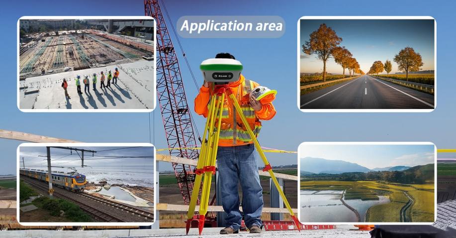
Applications of Topographic Surveying
Topographic surveying’s precision terrain mapping has far-reaching implications for a multitude of industries and projects, amplifying their efficiency, safety, and exactness. Here are some pivotal applications:
- Construction and Engineering: Topographic surveys are useful in guiding the planning and execution of infrastructure projects. Ensuring structural stability and precise elevation control are essential.
- Urban Planning: Urban planners use terrain data. Integrate elements such as drainage systems, transportation networks and land use to create a sustainable urban landscape.
- Agriculture: Precision agriculture uses topographic maps to optimize irrigation, crop cultivation and resource distribution. This increases yields and conserves resources.
- Environmental Conservation: Topographic surveys help monitor and protect ecosystems. This enables tracking of landscape changes and planning of conservation initiatives.
- Forestry: In the realm of forestry management, precise terrain mapping supports sustainable logging practices, aids in forest inventory management, and promotes the preservation of wildlife habitats.
- Mining and Minerals: Topographic information plays a pivotal role in mining operations, guiding excavation, waste management, and the evaluation of environmental impacts.
- Land Development: Real estate developers rely on topographic surveys to evaluate land suitability for construction, devise subdivisions, and adhere to zoning regulations.
- Floodplain Management: Accurate elevation data is instrumental in modeling flood risk, overseeing floodplains, and implementing flood control strategies.
Accurate terrain mapping, a cornerstone of topographic surveying, lays the foundation for informed decision-making across these diverse sectors. It fosters sustainable development and astute resource management, underpinning a wide spectrum of projects and industries.
Partner with SMAJAYU for Precision Terrain Mapping Excellence
In the realm of precision terrain mapping, SMAJAYU stands as a beacon of excellence. Our topographic surveying services, fueled by advanced technology and a seasoned team, offering unparalleled accuracy and reliability. From construction to conservation, our commitment to mapping the terrain with precision has a transformative impact on diverse industries. With SMAJAYU, you’re not just getting surveying services; you’re gaining a partner dedicated to the success of your projects and the sustainable management of our world’s invaluable landscapes. Trust us to guide you through every contour with unwavering precision and expertise.
