

Accurate and reliable measurements are crucial in surveying, and having the right equipment plays a vital role in achieving precision and efficiency. Among the essential tools for modern surveyors is a survey GPS (Global Positioning System). The market offers a wide range of options, each with its own features and capabilities. To make an informed decision, it is important to consider several factors before investing in a survey GPS.
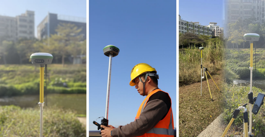
In the field of surveying and engineering, the demand for high-precision positioning has never been greater. Professionals rely on accurate data to ensure the success of projects and make informed decisions. Enter the R26 Surveying System Rover+Base, a cutting-edge GPS solution developed by SMAJAYU. In this blog post, we will explore some key tips to help you choose the right survey GPS for your specific needs, with a focus on SMAJAYU as a reputable supplier.
Understanding Your Requirements:
1. Determine the Required Accuracy Levels:
The first step in selecting a survey GPS is understanding the accuracy levels you need for your projects. Different applications may have varying accuracy requirements, ranging from centimeter-level precision for engineering projects to sub-meter accuracy for general mapping purposes. Clearly defining your accuracy needs will help narrow down the options.
2. Consider the Project Environment and Conditions:
Surveying projects can take place in diverse environments, including urban areas, dense forests, or rugged terrains. Evaluate the environmental conditions you frequently work in, such as poor satellite reception or challenging weather conditions. Look for a survey GPS that can handle these conditions effectively and provide reliable results.
Evaluating the Survey GPS Features:
1. GNSS Technology:
The Global Navigation Satellite System (GNSS) is at the heart of a survey GPS. Look for devices that support multiple satellite systems, such as GPS, GLONASS, Galileo, and BeiDou, as this enhances positioning accuracy and availability, especially in challenging environments. SMAJAYU offers survey GPS models equipped with advanced GNSS technology, ensuring superior performance.
2. Real-Time Kinematic (RTK) Capability:
RTK is a technique used to enhance the accuracy of GPS positioning. It involves the use of a base station and a rover to provide real-time corrections, resulting in centimeter-level accuracy. If your projects require high precision, consider a survey GPS with RTK capability. SMAJAYU offers RTK-enabled survey GPS units that deliver exceptional accuracy.
3. Data Collection and Integration:
Consider the ease of data collection and integration with your existing surveying workflow. Look for a survey GPS that allows seamless data transfer to your preferred software and supports standard file formats like NMEA or RINEX. SMAJAYU provides user-friendly survey GPS devices that facilitate efficient data collection and integration.
Considering Practical Aspects:
1. Durability and Robustness:
Surveying work can be demanding, involving exposure to harsh environments and potential accidents. Choose a survey GPS that is rugged and built to withstand such conditions. SMAJAYU offers durable survey GPS units that are resistant to dust, water, and impact, ensuring long-lasting performance in the field.
2. Battery Life and Power Management:
A reliable battery life is essential for uninterrupted surveying operations. Assess the battery capacity and power management features of the survey GPS to ensure it can sustain your work requirements without frequent recharging. SMAJAYU offers survey GPS devices with extended battery life and efficient power management capabilities.
Supplier: SMAJAYU – Empowering Precision in Surveying
SMAJAYU, a reputable name in the industry, has designed the R26 Surveying System Rover+Base to cater to the needs of professionals who demand exceptional precision and reliability in their surveying endeavors. With years of expertise and innovation, SMAJAYU has become a trusted supplier, providing advanced solutions to the surveying and engineering community.
1. Unmatched Precision and Accuracy:
The R26 Surveying System Rover+Base stands out for its unparalleled precision and accuracy. Equipped with a GNSS receiver, it harnesses SMAJAYU’s new GNSS global corrections service, which is delivered via band satellite and internet. This advanced technology enables the R26 to achieve centimeter-level positioning accuracy, ensuring precise measurements and dependable results.
2. Support for Multi-Satellite Systems:
To enhance its performance, the R26 system supports multi-satellite systems and offers full-band satellite signal reception. This capability allows the receiver to track signals from various satellite constellations, including GPS, Glonass, BeiDou, Galileo, and QZSS. By maximizing the availability of satellite signals, the R26 ensures robust and reliable positioning, even in challenging environments.
3. Engineered for Field Use:
Recognizing the importance of field usability, SMAJAYU has engineered the R26 Surveying System Rover+Base with durability and practicality in mind. The integrated design includes a built-in large-capacity battery and a large-capacity memory card, enabling extended operation in the field without interruption. The system is also equipped with a range of modules, including Bluetooth, inertial navigation, and radio, to facilitate seamless communication and data transfer.
4. Versatility for Various Applications:
The R26 Surveying System Rover+Base is not limited to a single application. It finds utility in a range of industries and projects. Whether it’s agricultural systems, intelligent spray systems, leveling systems, or RTK surveys, the R26 delivers exceptional results. Its versatility and adaptability make it a go-to solution for professionals across different sectors.
5. Easy Integration and Connectivity:
SMAJAYU understands the importance of compatibility and ease of use. The R26 Surveying System Rover+Base supports various file formats for import and export, allowing seamless integration with existing software and workflows. This flexibility ensures a smooth transition for professionals who are already accustomed to specific data formats and processing methodologies.
Conclusion:
In the world of surveying and engineering, precision is paramount. The R26 Surveying System Rover+Base, developed by SMAJAYU, is a game-changer in achieving centimeter-level positioning accuracy. With its advanced GNSS technology, multi-satellite support, and robust design, the R26 empowers professionals to elevate their surveying capabilities to new heights. If you’re looking for a cutting-edge survey GPS solution, the R26 is undoubtedly worth considering. Experience the future of surveying with the R26 Surveying System Rover+Base.
