

What does RTK solution GPS mean?
- Instantaneous kinematic RTK solution GPS are a class of exact positioning technologies that offer quick, precise answers for surveying, mapping, and other applications. This piece discusses the benefits of RTK solutions and some of the sectors in which they may be applied.
- Actual Kinematic “RTK technology provides the precision of up to a few centimeters by utilizing satellite positioning systems. RTK, a more sophisticated type of GPS, is used in surveying and building projects to offer more precise measurements of distances, angles, and heights.
What does RTK mean?
“Real-time kinematic” (RTK) is the abbreviation. It is a method of satellite navigation used to improve the accuracy of location information obtained from satellite-based positioning systems (like GPS). In RTK, users get real-time updates on the location of GPS satellites via a network of reference stations that continually track their position. To pinpoint a receiver’s location on the ground, a satellite’s signals are used in this precise surveying technique.
How does RTK function?
- A surveying technique called Real-Time Kinematic (RTK) surveying employs satellite signals to get precise measurements. It is frequently utilized in engineering and construction applications where great precision is necessary. RTK surveying determines the position of the surveying equipment by using signals from a satellite.
- GNSS receivers pick up the signals broadcast from a constellation of satellites orbiting the Earth. The fundamental notion underlying RTK is that the GPS receiver may attain sub-meter precision by employing a stationary base station to offer corrections.
What factors does RTK depend on?
To achieve this degree of precision, RTK relies on GPS receivers. Our farmers and agribusinesses can supply seeds and fertilizer to certain areas of their fields because of this razor-sharp precision, enhancing the overall output of their farms. RTK precision farming also helps farmers and agribusinesses track how their crops grow throughout the growing season. However, RTK heavily relies on all the data they have collected regarding choosing which crops to harvest, using land as efficiently as possible and minimizing agricultural waste.
Satellite measurements are sent from a fixed reference station to neighbouring receivers to construct an RTK solution. They can eliminate typical inaccuracies by integrating their data with the reference station, whose precise position is known (ionosphere errors, satellite clock errors etc.). It will utilize the phase measurements to pinpoint an accurate position within 2–5 centimeters once these inaccuracies have been eliminated.
Farmers’ benefits from RTK in agriculture:
Farmers that utilize RTK solution GPS in agriculture can use it for many different things, including drainage, drip irrigation, ground levelling, planting, seeding, and spraying. These applications can be utilized to achieve broad objectives or more specific ones. Using RTK in precision agriculture has various advantages, some of which are listed below.
- The total efficiency of the field has increased as the quantity of overlapping has decreased.
- A considerable sum of additional money must be set aside for operational resources like fertiliser.
- Spending more time in the field—possibly well into the evening is possible.
- One can save fuel costs by using the equipment to its fullest potential.
- Not only in the absence of light but also the presence of light, is reliability possible.
- Consistent performance is achieved when Farmers and Growers use Real-Time-Knowledge GPS Receivers.
Urban farming and commercial agriculture may benefit in various ways from using RTK GPS technology. They can use GPS surveying equipment to map out their crops to use the information for machine management or autonomous driving in the future.
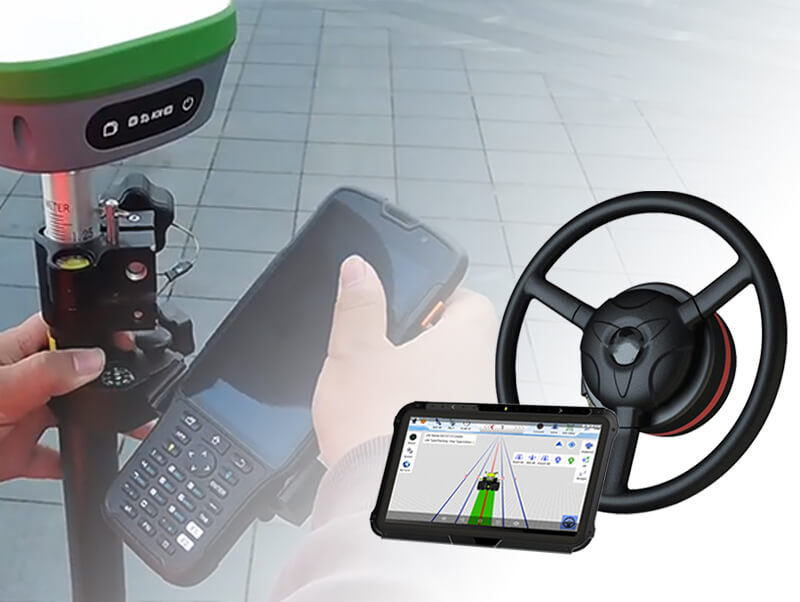
SMAJAYU is a straightforward and knowledgeable organization that offers farmers easy and cost-effective Agriculture RTK GPS to suit their mapping and surveying requirements.
Real-Time Kinematic (RTK) technology is utilized:
The farmers can determine an object’s location and orientation by using Real Time Kinematic (RTK) technology sensors. Real-time kinematics technology has become more prevalent in agricultural settings during the past few years. The main drivers of this expansion are advances in crop yields and planting efficiency in agriculture. Real-time kinematic precision agriculture is a method that allows farmers and other agricultural enterprises to create detailed maps of their farms. They can manoeuvre their tractors and other farm machinery with increased accuracy. This technology is necessary for precise crop mapping and crop management.
The merits of agriculture RTK:
Farm-scale for farmers, Real-Time Kinematic GPS (RTK) presents a lot of potential advantages. RTK can assist farmers in maximizing their inputs and increasing yields by giving more precise information about field conditions. RTK may also be used to map fields automatically, follow machinery, and keep an eye on crops.
- Higher precision:
Farm-scale A GNSS technique called Real-Time Kinematic (RTK) improves precision for agricultural applications. The system is based on a base station placed on the farm, which corrects GNSS receivers installed in agricultural machinery.
Improved effectiveness: If you are a farmer, you are aware of the importance of effectiveness. Farmers may become more productive using Real-Time Kinematic GPS devices, which provide them with more precise information about their farms. These solutions can lower input costs for farmers while also boosting yields. Using this technology, farmers might have access to real-time information on their crops, soil, equipment location, and other things.
Conclusion:
The positioning technique known as RTK solution GPS offers an exact positioning solution. It employs a base station and a rover in conjunction to attain centimeter-level precision and is based on the Global Positioning System (GPS). When SMAJAYU was constructed in 2009, technology had already undergone a 10-year transition from conventional to innovative equipment. Our new objective to help agricultural growth was made possible by intelligent agriculture. The use of agricultural technology on all sizes of farms is boosted by the high-precision and reasonably priced RTK GNSS system. Precision farming to a centimeter is ensured with SMAJAYU agriculture guidance and auto-steer, which are integrated with GPS accuracy technology.
