JYL20 GNSS Land Leveling Machine is an advanced machine for leveling land. It is used for leveling land in construction projects and agricultural fields. This machine is equipped with GPS and GNSS technology which makes it very accurate and efficient in leveling land.JYL20 GNSS Land Level.
The technology is particularly well suited for large-scale projects, such as those undertaken by governments or development organizations, where the objective is to improve agricultural productivity or infrastructure development.
What is GNSS land leveling?
Land leveling, also called land grading or land formation, is the process of changing land elevation to the desired grade. The primary purpose of land leveling is to improve agricultural production and drainage. GNSS-based land leveling has become an important technology in recent years due to its accuracy and efficiency.
GNSS land leveling is the process of using GPS or other satellite-based positioning systems to determine the elevation of a piece of land. This information can then be used to create a map of the land’s surface, which can be used for a variety of purposes such as agricultural planning, construction, and surveying.
GNSS Land Leveling – How Does It Work?
GNSS Land Level is a surveying method that uses the global positioning system (GPS) to determine the elevation of a particular point on the Earth’s surface. This technology can be used to measure the height of mountains, buildings, and other structures, as well as to map the contours of the land.
GNSS land leveling is an efficient and accurate way to level land for construction projects, agricultural purposes, or any other type of land development.
Applications of GNSS Land Leveling
The Global Positioning System (GPS) is a space-based satellite navigation system that provides location and time information in all weather conditions, anywhere on or near the Earth where there is an unobstructed line of sight to four or more GPS satellites
- Landscaping
GNSS land leveling is a process that uses global navigation satellite systems (GNSS) to create a level surface. This process is often used in landscaping and construction projects. There are many benefits to using GNSS land leveling, including improved accuracy, faster leveling, and the ability to level on slopes.
GNSS land leveling is important in landscaping because it helps to create level surfaces, which are necessary for proper drainage and irrigation.
- Farmland
Farmland is one of the most important economic resources in the world. The efficient use of farmland is essential for food security and economic development. One of the key factors in efficient farmland is land level. Land level influences many aspects of farming, including tillage, planting, irrigation, drainage, and yield.
The application of GNSS for leveling in farmland has attracted more and more attention in recent years. This technology has the advantages of high accuracy, wide coverage, and real-time monitoring, which can meet the needs of modern agricultural production.
- Construction
The use of GNSS equipment in construction projects has many benefits, including increased accuracy and efficiency in leveling, surveying, and excavating. GNSS systems can also be used to create 3D models of construction projects. The process is used to prepare construction sites for buildings, roads, and other infrastructure projects.
The benefits of GNSS Land leveling
GNSS-based land leveling is a technology that can be used to create more level fields, which can result in increased yields, improved water management, and a reduction in input costs.
The main purpose of land leveling is to create a level field surface, which is essential for modern farming equipment and techniques. GPS-based land leveling systems have revolutionized the process of land leveling, making it more efficient and accurate.
- Reduced soil compaction problem
GNSS land leveling is a technology that can be used to create a more level surface, which can in turn reduce soil compaction problems.
Soil compaction is a big problem for farmers. It reduces crop yields, increases fuel costs, and damages equipment. GNSS-based land leveling is a new way to reduce soil compaction. It uses GPS to measure the elevation of the land and then adjusts the amount of leveling material applied to the land.
- Reduced costs
GNSS land leveling is a technology that can be used to quickly and accurately level land. GNSS land leveling can save you money by reducing the amount of time and labor required to level your land. This technology can also help you avoid costly mistakes, such as leveling your land too high or too low. This technology can be used to reduce the cost of land leveling by up to 50%. GNSS land leveling can also be used to improve the efficiency of land leveling by up to 30%.
- Reduced water usage
The benefits of GNSS land leveling are many, but the most important is the significant reduction in water usage that can be achieved. With proper land leveling, farmers can reduce their water usage by as much as 30%. This not only conserves water but also reduces the amount of energy required to pump water to the fields.
- Increased crop yields
The use of Global Navigation Satellite Systems (GNSS) to create a digital terrain model (DTM) and carry out land leveling has increased in recent years. This technology provides an efficient and accurate means to create a level field surface, which can result in increased crop yields.
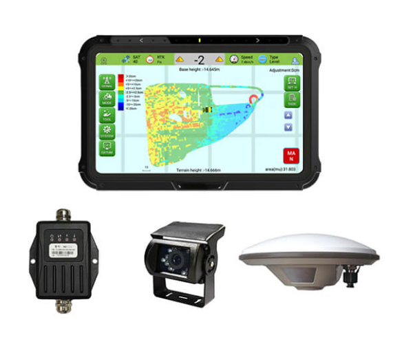
SMAJAYU JYL20 GNSS Land level: Technical Specifications
The SMAJAYU JYL20 GNSS Land level is a GNSS land level instrument that can be used to measure heights, distances, and angles. It can be used to set up and maintain GNSS control networks, as well as to measure topographic features and monitor deformation. The system includes a GNSS receiver, antenna, and display, and is capable of leveling up to 20 hectares (50 acres) of land. With its built-in GPS receiver, the JYL20 can provide accurate readings of up to 10 meters. In short, sThe SMAJAYU JYL20 is the perfect tool for those who need to find the altitude of a particular location.