

SMAJAYU, established in 2009, has thrived through a decade marked by transformative technological advancements. Evolving from traditional devices to cutting-edge smart equipment, SMAJAYU found its new mission in driving agricultural development. In this pursuit, the company harnessed high-precision and cost-effective Real-Time Kinematic (RTK) GNSS systems, catalyzing the adoption of advanced farming technologies across farms of all sizes. Topographic GPS mapping plays a pivotal role in this journey. By seamlessly integrating GPS accuracy technology, SMAJAYU’s agricultural guidance and auto-steer systems deliver centimeter-level precision in farming practices.
What is Topographic GPS Mapping?
Unveiling Topographic Mapping
Topographic mapping is the intricate process of crafting meticulous, three-dimensional renditions of Earth’s surface. These maps vividly display nature’s wonders, like mountains, valleys, rivers, and lush forests, alongside the man-made marvels of roads, buildings, and infrastructure. They offer a comprehensive panorama of terrain elevations, contours, and geographic traits. Topographic maps serve as indispensable tools across diverse domains, including urban planning, environmental assessment, geological exploration, and land management.
Pivotal Role of GPS Technology in Topographic Mapping
Modern topographic mapping hinges on the bedrock of GPS (Global Positioning System) technology. Anchored in a constellation of orbiting satellites, GPS broadcasts signals to receivers on Earth. These receivers meticulously compute their exact coordinates, drawing from the transmissions of multiple satellites. Harnessing GPS technology, surveyors and cartographers can precision-map locations, elevations, and geographic intricacies. This spatial data seamlessly melds into topographic maps, ensuring their noteworthiness not only for their intricate detail but also for their geo-referenced, high-fidelity accuracy.
Benefits from Precision Topographic Data
Accurate topographic data ushers forth a myriad of advantages across varied domains:
- Urban Planning: Facilitates zoning decisions, infrastructure evolution, and disaster readiness.
- Agriculture: Enhances crop strategies, irrigation, and land stewardship via elevation and contour insights.
- Environmental Conservation: Empowers habitat assessment, watershed stewardship, and ecological exploration.
- Infrastructure Design: Supports engineers in road networks, utilities, and construction blueprints.
- Navigation and Exploration: Safeguard hikers, climbers, and adventurers navigating rugged terrains with confidence.
SMAJAYU’s Topographic GPS Technology
Overview of SMAJAYU’s GPS Mapping Solutions
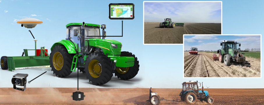
SMAJAYU’s innovative JYL20 system comprises a comprehensive suite of components designed for precise GPS mapping and land leveling. The system includes a control table, a high-precision controller, an HD camera, the A10 GNSS antenna, and the GNSS LAND LEVELING software. Its compatibility extends to multiple scraper machines, making it adaptable for a wide range of applications. Notably, it demonstrates robust performance even in challenging sand and dust-prone environments. SMAJAYU’s technology enhances operational efficiency by up to 20%, and its scalability allows for the integration of auto-steering, guidance, and smart sprayer functionalities.
Features and Capabilities of SMAJAYU’s Technology
The JYL20 GNSS land leveling system distinguishes itself with its exceptional precision, high performance, and user-friendly visual operation map. It serves as a versatile replacement for traditional laser graders, seamlessly adapting to common leveling equipment such as shovels, scrapers, bulldozers, and graders. This system empowers operators with guidance and control capabilities, ensuring precise leveling operations while significantly reducing operator fatigue and skill requirements. It is a valuable tool for a wide array of tasks, including leveling farmland, transforming grid fields, reclaiming wasteland, converting dry land, and achieving precise ground surface leveling.
How SMAJAYU’s Technology Stands Out in the Market
SMAJAYU’s technology sets a new standard in the market for topographic GPS mapping and land leveling. Its competitive edge lies in several key areas:
- Precision and Performance: SMAJAYU’s system offers unparalleled accuracy, making it ideal for demanding leveling tasks.
- Versatility: The technology seamlessly integrates with a variety of leveling machinery, providing flexibility and adaptability for diverse applications.
- Ease of Use: The user-friendly visual operation map simplifies the leveling process, reducing the need for extensive technical expertise.
- Efficiency Boost: Operators can achieve higher levels of efficiency, resulting in time and cost savings.
- Scalability: SMAJAYU’s system can be expanded to include additional functionalities such as auto-steering, guidance, and smart sprayer integration, enhancing its value for users.
Applications of SMAJAYU Topographic GPS Mapping
- Agriculture: SMAJAYU’s technology enhances precision farming by providing accurate elevation data. Farmers can optimize irrigation and soil management, resulting in higher crop yields and resource efficiency.
- Construction: In the construction industry, SMAJAYU facilitates precise land grading and site preparation, reducing material waste and ensuring stable foundations for structures.
- Environmental Monitoring: SMAJAYU aids in ecological studies, allowing researchers to assess habitats, manage watersheds, and monitor environmental changes over time.
- Mining: Mining operations benefit from SMAJAYU’s accurate terrain analysis, streamlining resource exploration and extraction efforts while minimizing environmental impact.
- Land Development: Urban planners utilize SMAJAYU’s solutions for zoning decisions and efficient land transformation projects, ensuring sustainable growth.
- Forestry: Forestry professionals can employ SMAJAYU to manage timber resources, plan harvesting activities, and protect forest habitats.
- Surveying and Mapping: The technology is invaluable for geospatial data collection, enabling precise cartography and map creation.
- Disaster Management: SMAJAYU’s terrain analysis supports disaster preparedness, helping authorities plan for and respond to natural disasters effectively.
Benefits of Using SMAJAYU
Cost-efficiency and Time Savings
SMAJAYU’s technology offers remarkable cost-efficiency and time savings. With land leveling accuracy reaching an impressive ±2.5cm, it minimizes the need for rework and ensures optimal resource utilization. The system’s operation track and high/low terrain mapping provide an intuitive, real-time view of the work, resulting in a substantial 30% increase in leveling efficiency. Moreover, the absence of a requirement for a base station and unrestricted working distances further contribute to cost reduction and time savings.
Improved Accuracy and Precision
SMAJAYU’s technology is synonymous with accuracy and precision. Achieving a land leveling accuracy of ±2.5cm ensures that tasks are carried out with meticulous attention to detail. The system’s ability to automatically identify terrain and adjust plot datum enhances precision, improving operational efficiency by an additional 20%. This level of accuracy is a game-changer in applications where precision matters, such as agriculture and construction.
Enhanced Decision-making Capabilities
SMAJAYU empowers users with data-driven decision-making capabilities. The system’s operation track and terrain mapping provide valuable insights in real-time, enabling operators and managers to make informed choices on the go. This enhanced decision-making capability not only boosts efficiency but also ensures that resources are allocated optimally, contributing to overall project success.
Unlock the Future of Precision Mapping with SMAJAYU
SMAJAYU’s Topographic GPS Mapping technology shines as a symbol of precision and efficiency across a wide range of industries. Its exceptional accuracy, cost-effectiveness, and versatility empower users to make informed choices, maximize resource utilization, and excel in their specific domains. Whether applied in agriculture, construction, environmental monitoring, or other areas, SMAJAYU’s solutions push boundaries and pave the path toward a future marked by intelligent and sustainable practices.
