

What does the term “GPS surveying equipment” mean?
GPS surveying equipment refers to the specialized machinery and instruments that land surveyors and other experts use to conduct precise and accurate surveys utilizing the Global Positioning System (GPS). With the aid of this gear, surveyors may pinpoint the precise geographic coordinates (latitude, longitude, and altitude) of various locations on the surface of the Earth. “GPS surveying equipment” refers to a broad category of tools and accessories used to record, process, and analyze GPS signals to produce precise position data for various uses, such as engineering, mapping, land development, and more. The following are important GPS surveying equipment parts:
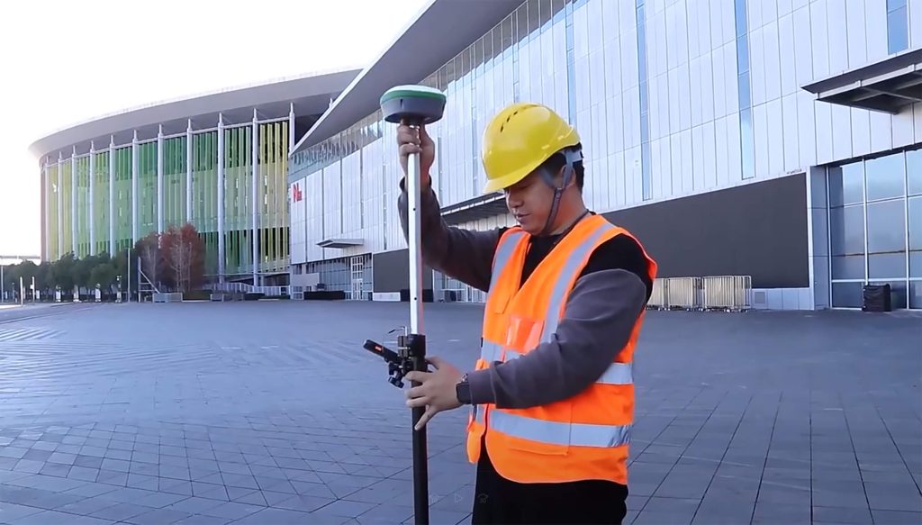
- These are portable or mounted gadgets that pick-up signals from GPS satellites. They determine locations based on the time signals are transported from satellites to the receiver.
- GPS signals are captured using high-precision antennas. These antennas are made to maximize accurate reception while reducing signal interference.
- GPS receiver data is collected via data collectors, which are portable electronic devices or tablets. Touchscreens and specialized software for data entry and administration may be available.
- A base station with a known position is utilised to provide corrective data to increase the accuracy of surveying GPS receivers using differential GPS (DGPS).
- To increase the precision of GPS readings, correction services like Real-Time Kinematic (RTK) corrections offer real-time data.
- Sturdy tripods and mounting hardware keep GPS antennas and receivers in place while collecting data.
- Extendable poles are used in surveying to reach particular survey locations and elevate GPS antennas for improved satellite reception.
Using GPS Surveying Equipment to Its Full Potential: Revolutionizing Accuracy and Efficiency
Gps surveying equipment has significantly improved efficiency and accuracy, revolutionizing the field of land surveying. This technology, which uses signals from a network of satellites circling the Earth, has completely changed how surveys are conducted and given surveyors access to previously unattainable advantages. Let’s explore how GPS surveying technology has unleashed its potential and sparked these radical transformations.
- Unmatched precision:
GPS surveying equipment provides unmatched precision compared to conventional surveying techniques. Surveyors can collect very accurate data points by locating sites with centimetre-level accuracy. This degree of precision is critical for projects to succeed across various sectors, including construction, civil engineering, and land development.
- Efficiency:
Traditional surveying techniques require time-consuming fieldwork, manual measurements, and information gathering. GPS surveying equipment drastically reduces the amount of time required for these operations. Surveyors can gather more information in less time, which expedites project completion and lowers labour expenses.
- Usefulness:
GPS surveying equipment has evolved to become more user-friendly. Data collection, processing, and analysis are frequently streamlined by modern systems’ user-friendly software and interfaces. Both novices and seasoned surveyors may easily collect reliable data because of its ease of use, which requires minimal training.
- Versatility:
This surveying equipment is adaptive and versatile and may be used for various surveying activities. GPS technology can accurately manage surveying requirements, measuring borders, heights, angles, and distances. Due to its adaptability, it is an indispensable tool for projects of various sizes and complexity levels.
- Remote Surveying:
Remote surveying is one of the most important developments of GPS surveying. Surveyors may now gather data from hard-to-reach or remote sites without being there. This capacity is especially helpful in risky or challenging circumstances.
- Real-Time Data:
Several contemporary GPS surveying devices offer real-time data gathering and feedback. This enables surveyors to make quick modifications, confirm measurements, and immediately verify the correctness of their work. Real-time data makes collaboration between surveying teams, engineers, and project stakeholders easier.
- Data Integration and Analysis:
Geographic Information Systems (GIS) and other mapping applications may quickly integrate the data that GPS surveying equipment produces. This connection provides more thorough analysis, visualization, and decision-making throughout the project’s lifetime.
- Cost reductions:
Although GPS surveying equipment may need a larger initial investment than conventional instruments, significant long-term cost reductions exist. Improved project economics result from quicker completion, lower labour costs, and fewer mistakes.
- Environmental Impact:
The effectiveness of GPS surveying equipment results in less site disturbance, less fuel consumption, and less environmental impact. This supports ecologically conscious surveying methods and is consistent with sustainability objectives.
What is the process of GPS surveying?
A network of satellites in orbit around the Earth is used in GPS surveying, sometimes called Global Positioning System surveying, to pinpoint exact locations and coordinates on the planet’s surface. The fundamental idea underlying GPS surveying is to time how long signals travel from various satellites to a GPS receiver on the ground. The GPS receiver can estimate its location with great precision by calculating these time differences and using the known locations of the satellites. A GPS receiver is used on the ground to receive signals from the GPS satellites. An antenna to pick up these signals and internal processing devices make up the receiver.
SMAJAYU: A Reliable Manufacturer
- Wide Product Selection:
JY100 Guidance System, Intelligent Spray System, Autosteering System, and Levelling System are just a few of the systems SMAJAYU provides. Customers may be confident we will discover the ideal solution to meet their unique demands thanks to our product selection.
- Customization Possibilities:
SMAJAYU is aware that every application could have particular needs. We provide customisation possibilities to allow clients to customize their GPS navigation systems to meet their unique demands. This adaptability guarantees top performance and improves user experience.
- Sturdy and Reliable Systems:
The Gps surveying equipment from SMAJAYU is made to survive tough situations. Our systems are made with an emphasis on quality and longevity to deliver dependable performance, assuring continuous operation even under challenging circumstances.
Conclusion:
When looking at Gps surveying equipment GPS guidance systems, SMAJAYU stands out as a reliable vendor that provides an extensive selection of first-class goods designed to satisfy the demands of numerous industries. You may make an educated choice and ensure the effective integration of GPS navigation systems into your operations by being aware of your needs, investigating reputable providers, and considering SMAJAYU as a dependable alternative. Choose the proper source carefully to get dependable, precise, and effective positioning solutions.
