

Global Navigation Satellite System (GNSS) survey equipment has become the cornerstone of modern surveying and mapping applications. These high-tech instruments have revolutionized the way we collect geospatial data, offering unparalleled accuracy and efficiency.
When it comes to GNSS survey equipment, SMAJAYU is a reputable manufacturer known for its commitment to quality and precision. Their equipment combines cutting-edge technology, robust construction, and user-friendly interfaces to meet the diverse needs of surveying professionals.
GNSS Survey Equipment: Meeting the Needs of Modern Surveying
1. GNSS Survey Equipment: Precise Positioning
The primary need met by GNSS survey equipment is precise positioning. Whether it’s for land surveying, construction layout, or mapping applications, knowing the exact location of a point on the Earth’s surface is crucial. GNSS technology, which relies on a constellation of satellites, ensures centimeter-level accuracy in real-time, making it an indispensable tool for professionals.
2. GNSS Survey Equipment: Efficiency and Productivity
Surveyors and mappers are often pressed for time when collecting data. GNSS survey equipment significantly enhances efficiency by reducing fieldwork duration. With real-time positioning and advanced data collection capabilities, it streamlines workflows and allows for quicker decision-making.
3. GNSS Survey Equipment: Versatility and Integration
The needs of surveying professionals are diverse. GNSS survey equipment caters to this by offering versatility in its applications. It can be used for topographic surveys, cadastral mapping, construction site layout, and more. Additionally, it seamlessly integrates with other surveying tools and software, facilitating a comprehensive approach to data collection and analysis.
GNSS Survey Equipment: Addressing Challenges with Precision
1. GNSS Survey Equipment: Overcoming Signal Obstructions
One of the major challenges faced in GNSS surveying is signal obstructions. Tall buildings, dense tree canopies, and rugged terrains can obstruct satellite signals, leading to inaccuracies. To address this issue, GNSS equipment, like SMAJAYU’s offerings, features multi-constellation and multi-frequency capabilities. This means it can receive signals from multiple satellite systems (GPS, GLONASS, Galileo, BeiDou) and adapt to different frequencies, ensuring continued accuracy even in challenging environments.
2. GNSS Survey Equipment: Minimizing Error Accumulation
GNSS surveys are prone to errors caused by factors such as atmospheric conditions and clock inaccuracies in satellites. Survey equipment manufacturers have implemented techniques like Real-Time Kinematic (RTK) and Post-Processing Kinematic (PPK) to minimize error accumulation. RTK corrects errors in real-time, while PPK corrects data after collection, enhancing the reliability of the collected data.
3. GNSS Survey Equipment: Data Quality Assurance
Data integrity and quality are paramount in surveying. The GNSS survey equipment from manufacturers like SMAJAYU incorporates data quality assurance features, including data logging and quality checks. This helps in identifying and rectifying anomalies during data collection, ensuring the final results are highly reliable.
Revolutionizing Industries with GNSS Survey Equipment: SMAJAYU Leading the Way
1. Mechanical Control: Precision at Your Fingertips
Mechanical control applications often require pinpoint accuracy. Whether in construction, mining, or industrial operations, ensuring the right machinery is at the right place is crucial. GNSS survey equipment by SMAJAYU provides real-time positioning and high precision, making it an invaluable tool in mechanical control. This technology allows operators to streamline their work, reducing errors and increasing overall efficiency.
2. Surveying and Mapping Engineering: Mapping the Future with GNSS
Surveying and mapping engineering demand the utmost accuracy. GNSS equipment not only accelerates the data collection process but also enhances the precision of gathered information. SMAJAYU’s equipment can be a surveyor’s best companion, enabling them to map intricate terrains and urban landscapes with ease, and facilitating the creation of detailed, accurate maps.
3. Precision Agriculture: Revolutionizing Farming Practices
In the world of agriculture, precision is the key to optimizing crop yields and resource management. GNSS survey equipment offers a lifeline to farmers and agronomists. SMAJAYU’s GNSS technology enables precise tractor guidance, variable rate application of fertilizers, and the creation of detailed field maps. This, in turn, increases crop productivity and minimizes resource wastage, aligning farming practices with sustainability and efficiency.
4. Geographic Information: The Backbone of Modern Decision-Making
Geographic information systems (GIS) play a pivotal role in decision-making across various sectors. GNSS technology, integrated with GIS, ensures accurate geospatial data. Professionals in urban planning, environmental management, and disaster response can harness the capabilities of GNSS equipment from SMAJAYU to make well-informed decisions based on real-time, high-precision location data.
5. Water Survey: Monitoring Water Resources with Precision
The importance of accurate water surveying cannot be overstated, especially in the face of increasing environmental challenges. GNSS survey equipment is instrumental in monitoring water bodies, assessing water quality, and tracking water flow. SMAJAYU’s GNSS solutions aid researchers, hydrologists, and environmentalists in acquiring precise data, leading to better water resource management and preservation.
6. Engineering Survey: Transforming Construction and Infrastructure
Engineering survey applications rely on exact measurements for designing and constructing infrastructure. GNSS survey equipment can provide the much-needed precision for these projects. With real-time positioning and high accuracy, professionals in civil engineering and construction can ensure that their structures are built with the utmost precision, reducing errors and enhancing safety.
SMAJAYU: A Pioneer in GNSS Survey Equipment
SMAJAYU, a leading manufacturer in the GNSS survey equipment industry, has been instrumental in addressing the diverse needs and challenges faced by professionals in mechanical control, surveying and mapping engineering, precision agriculture, geographic information, water survey, and engineering survey. With their state-of-the-art technology, SMAJAYU has made substantial strides in delivering stable performance, fast positioning speed, and high precision, making GNSS survey equipment an indispensable tool for modern applications.
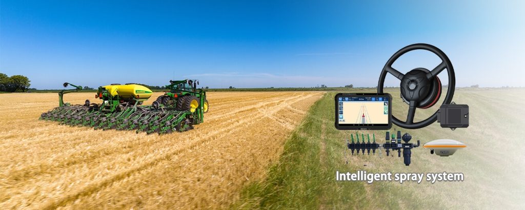
Product Advantages of JY100 Tractor GNSS Guidance System
1. High Precision Positioning: The system’s high-precision positioning board can achieve centimeter-level accuracy without the need to connect to a base station. This minimizes setup requirements and streamlines the farming process.
2. Cloud Job Information Storage: The system allows for cloud storage of job information, enabling real-time access to job data and job status. This facilitates remote management, providing farmers with the ability to monitor and manage their operations from anywhere.
3. Continuous 24-Hour Operation: The JY100 system can operate continuously for 24 hours, ensuring uninterrupted functionality even during night hours. This feature is essential for preventing operational failures due to nighttime conditions.
4. Support for GNSS Four-System Signals: The system supports GNSS signals from all four major global navigation satellite systems, enhancing its adaptability and reliability in various environments.
5. Strong Anti-Interference Capability: The JY100 boasts a strong anti-interference capability, allowing it to endure the harshest operating conditions and maintain reliable performance.
Conclusion
GNSS survey equipment has revolutionized various industries by addressing the critical needs for stable performance, fast positioning, and high precision. SMAJAYU’s commitment to innovation in this field has paved the way for enhanced efficiency, improved decision-making, and sustainable practices across mechanical control, surveying and mapping engineering, precision agriculture, geographic information, water survey, and engineering survey. As technology continues to advance, GNSS survey equipment will remain a vital tool for professionals in these sectors, reshaping the way they work and contributing to a brighter, more accurate future.
