

What is GNSS?
Because the term “GPS” is now often used to refer to satellite navigation systems in general, we need to exert extreme caution. The system created by the United States military is referred to by its acronym GPS, which stands for “Global Positioning Technology.” There are more systems to consider.GNSS Receivers
When talking about satellite navigation systems, the acronym GNSS, which stands for “Global Navigation Satellite System,” is a word that is often used. It is a generic phrase that may refer to any global constellation of satellites that broadcast signals for earth navigation. GNSS Receivers
GNSS Receiver:
When it comes to using satellite systems for measurement, there are important distinctions between words such as GPS and GNSS, even though the final result seems to be the same.
Electronic equipment known as GNSS receivers can receive signals from one or more GNSS satellite constellations and digitally process those signals to give the user location, velocity, and accurate time information (PVT). They act as the point of contact between the user and the GNSS.
Every GNSS and GPS satellite broadcasts a signal with a navigation message and several digital codes and carrier frequencies. Using the carriers and codes, the distance between the receiver and the GNSS satellite is then computed, and the navigation message comprises, among other things, information on the satellites’ positions over time.
Why are GNSS receivers so precise?
GNSS receivers determine their position by taking into account four different components:
- Their longitude
- Their latitude
- Their height
- Their clock inaccuracy.
The receiver’s ability to provide a navigational solution is contingent on the accuracy of the distance it calculates between itself and a constellation of satellites.
- GNSS Receivers are able to calculate the amount of time it will take for information sent from a satellite to reach them due to the fact that satellites are equipped with very accurate atomic clocks that govern the passage of data. Now that the precise satellite positions have been determined, the GNSS receiver is in a place to calculate the exact distance that separates it from the satellite.
- In order for GNSS receivers to be able to establish their position using at least four satellites, it is necessary for there to be a clear line of sight between the antenna of the receiver and the satellites themselves. It is possible that not all receivers will have the capability to use more satellites as they become available; nonetheless, this will result in an improvement to the location solution.
- The capability of the receiver to use additional satellite signals and the manner in which it does so will, of course, be impacted by the type of the receiver. Receivers also vary with regard to the kind of constellations that they track and the number of satellites that they track simultaneously. Receivers may be grouped together for use in a particular sector, such as agriculture or aviation, for example, and sold as a package deal.
In addition to providing users with accurate position information, GNSS receivers may also offer users exact time by synchronizing the local clock of the user with the incredibly accurate atomic clocks that are on board the satellites. This precise time is necessary for the synchronization of several systems, including electricity grids, the Internet, cellphone networks, and financial networks.
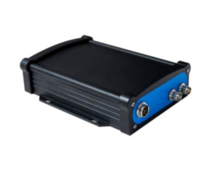
SMAJAYU R30 GNSS Receiver:
The integrated GNSS receivers inside the systems have been upgraded to the most recent version. The SMAJAYU R30 is a high-performance GNSS receiver that has been customized to meet the requirements of mining and agricultural businesses.
Due to the receiver’s compact size and extensive feature set, it is well suited for use in a wide range of high-precision locating applications. Some examples of these applications include RTK rovers, mobile field base stations, and the collection of post-processed data.
Advantages you will get if you own a SMAJAYU R30 GNSS Receiver:
- Option to include a radio or not have a radio.
- You have the choice of having built-in 3G or not having any 3G at all.
- The ubiquitous Ethernet interface makes it possible to send data through a network at a rapid rate.
- Provides support for a wide variety of modes of operation and may be configured to function either as a base station or as a mobile station.
GNSS Receiver Model R30 Compatibility Accessories:
- 2 GNSS Antenna
- 3 LAN Cable
- 1.5 Meters 4 5 RS-232 to TNC-TNC GNSS Data Cable, 10 Meters
SMAJAYU R23 GNSS Receiver:
The R23 RTK receiver stands out from the competition because of its remarkable accuracy, low power consumption, small size, and simplicity of transportability and usage. It combines the capabilities of a mobile RTK station with those of a stationary RTK base. To travel using the R23 system’s inertial navigation capabilities, An RTK receiver may perform the function of either a mobile station or a reference point because of its adaptability. It offers superior positioning and orientation capabilities across a wide variety of markets, such as mechanical control, surveying, and mapping engineering, precision agriculture, geographic information systems (GIS), water surveying, engineering surveying, mine surveying, aerial photography, uncrewed aerial vehicles (UAVs), and more.
Advantages you will get if you own a SMAJAYU R23 GNSS Receiver:
- An inertial navigation RTK is a high-precision, multi-functional RTK receiver with a rechargeable battery and storage.
- It also offers a higher degree of functionality than a standard RTK.
- Integrated antenna for full-frequency Beidou and GNSS, high-precision location and orientation board that works throughout the system, Bluetooth, and wireless networking.
GNSS Receiver Model R23 Compatibility Accessories:
- A cord with alligator clamps for electrical use
- 2 Linear Nine-Core Arrangement
- A power adapter, three electrical cables, and four extension poles are included in this package.
- Seven antennas at the end of line 6 R23 GNSS receiver
- disc
The Scope of Application of R30 and R23:
It is adaptable for usage in various agricultural machinery, such as tractors, harvesters, pesticide sprayers, rice transplanters, and many other types of machinery. It has a wide variety of uses, such as sowing seeds, cultivating land, digging trenches and ridges, spraying pesticides, transplanting plants, consolidating land, and harvesting crops, among other things.
Conclusion:
SMAJAYU has the availability of high-precision RTK GNSS systems at prices that are affordable for farms of varying sizes is a factor that contributes to an increase in the usage of agricultural technology.
The integrated GPS accuracy technology and automated guidance system that SMAJAYU offers now makes it possible to practice farming with a degree of precision that is measured in centimeters.
