

In today’s world, the demand for geographic surveying services has been steadily on the rise. This essential field has found applications in various industries, ranging from construction and agriculture to forestry and urban planning. To meet the positioning and orientation needs of these diverse sectors, innovative solutions like SMAJAYU’s R26 Radio RTK Base have emerged as valuable assets. In this blog, we’ll explore the growing demand for geographic surveying and delve into the impressive capabilities of the R26 Radio RTK Base offered by SMAJAYU.
The Booming Demand for Geographic Surveying
Geographic surveying plays a crucial role in modern society, facilitating informed decision-making, efficient resource management, and precision in numerous applications. As industries continue to evolve and embrace technology, the demand for high-precision geographic surveying tools has surged.
SMAJAYU, a leading manufacturer of geographic surveying equipment, is known for producing cutting-edge tools that cater to the diverse needs of the construction industry, agriculture, forestry management, and urban planning. Their commitment to innovation and precision has made them a trusted name in the field.
Rising Demand Points: Where Geographic Surveying is Essential
Wholesale geographic surveying is pivotal in various industries, and SMAJAYU provides the tools and solutions needed for accurate and reliable surveying. By following the outlined steps, professionals in construction, agriculture, forestry management, and urban planning can make informed decisions, optimize resource allocation, and contribute to sustainable and efficient operations.
1. Construction Industry: Geographic Surveying
Accurate positioning and orientation are fundamental in construction projects. Surveying aids in project planning, ensuring structures are built to exact specifications, and minimizing errors.
Geographic surveying is a cornerstone of the construction industry, ensuring that projects are executed with accuracy and efficiency. The following steps outline how SMAJAYU’s equipment is utilized in the construction sector:
a. Site Selection and Evaluation: Before starting a construction project, surveyors use SMAJAYU’s GPS equipment to choose the ideal site. This step involves assessing topography, soil quality, and accessibility.
b. Survey and Mapping: Surveyors use Total Stations, Laser Levels, and GNSS receivers by SMAJAYU to create detailed maps and 3D models of the construction area. This data helps in project planning and resource allocation.
c. Monitoring Progress: SMAJAYU’s monitoring solutions are crucial during construction. Continuous surveys ensure that the project is on track, helping to avoid costly delays and errors.
2. Agriculture: Geographic Surveying
Precision agriculture relies heavily on geographic surveying. By using accurate positioning data, farmers can optimize their operations, manage resources efficiently, and enhance crop yield.
Agriculture relies on geographic surveying for precision farming and resource management. SMAJAYU’s equipment aids in optimizing agricultural practices in the following ways:
a. Soil Analysis: Soil samples are analyzed using SMAJAYU’s tools, enabling farmers to determine nutrient levels, pH, and other factors crucial for crop health.
b. Field Mapping: GNSS technology is used for field mapping, helping farmers manage their land efficiently and plan crop rotation.
c. Irrigation Management: Geographic surveying assists in planning irrigation systems, conserving water, and ensuring uniform coverage of crops.
3. Forestry Management: Geographic Surveying
In forestry, surveying helps in tracking and managing forest resources. It enables efficient logging, boundary demarcation, and the development of sustainable forest management practices.
Effective forestry management is essential for sustainable resource utilization and environmental conservation. SMAJAYU’s geographic surveying equipment is integral in this sector:
a. Forest Inventory: Surveyors use LiDAR technology to create detailed forest inventories, facilitating the sustainable management of resources.
b. Wildlife Habitat Analysis: Geographic surveys aid in understanding wildlife habitats, helping conservationists protect endangered species.
c. Fire Risk Assessment: SMAJAYU’s equipment is employed to assess fire risk, allowing for proactive fire prevention measures.
4. Urban Planning: Geographic Surveying
Urban planners require precise geographic data for city development. Surveying helps determine the best locations for infrastructure and assess the environmental impact of urban projects.
In urban planning, geographic surveying is essential for designing efficient and sustainable cities. SMAJAYU’s equipment contributes to the following aspects:
a. Zoning and Land Use: Survey data is used to designate zones for residential, commercial, and industrial purposes, ensuring effective land use.
b. Infrastructure Development: SMAJAYU’s equipment assists in planning roads, utilities, and public spaces, leading to well-organized urban areas.
c. Environmental Impact Assessment: Urban planners use geographic surveying to assess and mitigate the environmental impact of urban development.
SMAJAYU’s Geographic Surveying Solution: The R26 Radio RTK Base
Amidst this growing demand, SMAJAYU, a prominent geographic surveying equipment manufacturer, has developed the R26 Radio RTK Base. Let’s explore the key features that make this device a game-changer in the field.
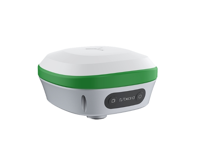
1. High Precision, Low Power Consumption
The R26 Radio RTK Base offers unparalleled precision while keeping power consumption to a minimum. This is critical for fieldwork, where long-lasting battery life and pinpoint accuracy are paramount. Users can trust this device to deliver consistently reliable results.
2. Compact and Portable Design
With its small and lightweight design, the R26 is easy to carry and operate in various environments. Surveyors no longer need to lug around heavy and bulky equipment, making fieldwork more convenient and less strenuous.
3. Freely Switch Between Base and Rover Modes
The R26 receiver is incredibly versatile, as it can seamlessly switch between base and rover modes. This adaptability is a boon for surveyors who require flexible equipment for different tasks and environments. It eliminates the need to invest in multiple devices.
4. Available in Abundance
With 999 units in stock, SMAJAYU ensures that the R26 Radio RTK Base is readily available to meet the surging demand for geographic surveying tools. This supply reliability is a valuable asset to professionals in the field.
5. Positive User Feedback
The R26 Radio RTK Base has earned a perfect 5-star rating, with 100% of users recommending it. This testimonial speaks volumes about the device’s quality and effectiveness in the field.
Conclusion: SMAJAYU – Pioneering Geographic Surveying Solutions
As the demand for geographic surveying continues to rise across various industries, SMAJAYU’s R26 Radio RTK Base emerges as a cutting-edge solution. With its high precision, low power consumption, compact design, and versatile operation modes, it perfectly addresses the needs of today’s surveyors. The 999 units in stock and exceptional user recommendations make it clear that SMAJAYU is a trusted leader in the geographic surveying equipment industry, providing professionals with the tools they need to navigate the world with precision.
