

What is RTK GPS Surveying Equipment, and why is it essential? RTK (Real-Time Kinematic) GPS technology delivers pinpoint accuracy for surveying by using a network of base stations and satellites to provide real-time corrections. This allows for centimeter-level precision, making it indispensable for tasks that demand high accuracy, such as land mapping, construction, and infrastructure development.

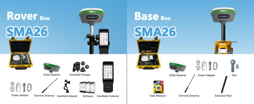
The SMA26 RTK Rover + Base is a versatile GNSS receiver tailored for the evolving needs of modern surveying. Featuring a built-in GNSS full-frequency antenna, high-precision positioning board, 4G connectivity, IMU, radio, and more, the SMA26 integrates advanced technologies into one powerful system, ensuring optimal performance and efficiency in the field.
Key Features and Specifications
RTK Accuracy
The SMA26 GNSS Surveying System is designed with high accuracy in mind. It includes the SMA26 rover, base station, and a collector with surveying software. The system uses two SMA26 RTK GNSS receivers. This setup allows it to quickly and accurately measure and reference locations. It can receive satellite signals from all constellations and frequencies. The system is also compatible with Beidou-3, enabling it to connect with over 40 satellites. This ensures accurate positioning even in complex environments. The system also tracks signals with 1408 channels, based on the NebulasIV platform.
SMA26 Rover + Base
The SMA26 can be used as both a mobile station and a base station. It has high precision but remains small and easy to carry. Its low power consumption makes it suitable for long-term use. The device is equipped with an intelligent system. This system supports various features like voice functions, an intelligent web platform (WEBUI), and self-test capabilities. The SMA26 can meet the positioning needs of many industries, including mechanical control, surveying and mapping, precision agriculture, geographic information, water surveying, engineering surveying, mine surveying, aerial photography, and drone operations.
NOAA Certification
The SMA26 comes with NOAA certification, which ensures the equipment meets strict standards. This certification assures surveyors and engineers that the system provides reliable and accurate data. The certification is essential for users who require the highest level of precision.
Additional Technical Specifications
The SMA26 has a large battery capacity. The built-in 10200mAh battery provides over 14 hours of continuous operation. This long battery life is essential for working in tough outdoor conditions. The device also has a built-in UHF wireless transceiver. This low-power wireless module enables automatic switching between mobile station and base station.
Wireless Protocol
The SMA26 uses the CSS (Lora) wireless protocol. This protocol ensures smooth communication between the rover, base station, and other devices.
Applications and Use Cases
Construction
The SMA26 GNSS system is ideal for construction projects. It provides precise measurements, which are essential for building roads, bridges, and other structures. The system helps ensure that all measurements are accurate and consistent.
Land Surveying
Land surveying often requires accurate boundary mapping and land development planning. The SMA26 system helps surveyors mark property lines and assess land for development. It is an essential tool for managing property and land projects.
Agriculture
In precision agriculture, the SMA26 GNSS system helps farmers manage their fields. It ensures that data collection is accurate, improving crop management and land use. The system can be used for tasks like planting, irrigation, and harvesting, all while optimizing field operations.
Infrastructure Projects
The SMA26 system is also useful for large-scale infrastructure projects. It plays a critical role in roadwork, bridge construction, and other civil engineering projects. The system ensures that all measurements are accurate and meet the necessary standards.
Benefits of NOAA Certification
What is NOAA Certification?
NOAA Certification ensures that equipment meets the standards set by the National Oceanic and Atmospheric Administration (NOAA). It guarantees that the device provides accurate, reliable data and complies with industry regulations. For surveying and GNSS systems, this certification assures users of precise positioning, even in challenging environments. It also confirms that the equipment has undergone rigorous testing to meet global quality and performance standards. This certification is essential for professionals who rely on accurate data for land surveying, engineering, and other technical applications.
Increased Trust and Accuracy
NOAA certification is important for users who need guaranteed accuracy. This certification assures users that the data from the SMA26 system is reliable and precise in all environments. It builds trust between equipment manufacturers and end-users.
Compliance and Regulatory Assurance
The SMA26 system meets all industry standards. With NOAA certification, users can be confident that they are using equipment that complies with necessary regulations. This is crucial for professional surveyors and engineers who must adhere to legal requirements. NOAA-certified equipment is trusted worldwide. It ensures that the SMA26 system can be used in various countries with consistent results. This certification allows users to rely on the equipment for accurate and compliant results, no matter where they work.
Quality Assurance and Performance
Overview of Quality Control Standards
The SMA26 system is built to meet high-quality standards. The product undergoes strict quality control during manufacturing. This ensures that each unit performs at its best. The system’s durability and reliability are tested before it reaches the market.
Testing Procedures
The SMA26 system is tested in different environmental conditions. It is checked for performance in various settings, such as extreme temperatures and harsh weather. These tests ensure that the equipment can handle real-world challenges. The system is built to last and deliver reliable performance under any condition.
Closing Words
The SMA26 RTK Rover + Base is a reliable and versatile tool for precise positioning and measurement. With its built-in GNSS antenna, high-precision board, and compatibility with multiple satellite constellations, it ensures accurate data even in complex environments. Its compact design, long battery life, and advanced features like voice support and web platform make it easy to use in various industries. The NOAA certification adds further trust, guaranteeing the equipment meets strict standards for accuracy and reliability. Whether for construction, land surveying, agriculture, or infrastructure projects, the SMA26 offers valuable solutions to professionals in need of high-quality surveying equipment. Its performance, ease of use, and global applicability make it a top choice for accurate fieldwork.
