

In an era where the wave of digitalization is sweeping across every industry, centimeter-level positioning technology is emerging as a core driving force behind agricultural modernization and intelligent engineering. As a leading brand specializing in high-precision GNSS/RTK solutions, SMAJAYU offers a full-stack product line spanning three key domains—precision agriculture, surveying and mapping, and hydrological monitoring—providing users worldwide with comprehensive, high-precision operational support ranging from the fields to the open wilderness.
- Precision Agriculture: Ensuring Every Inch of Land Is Treated with Precision
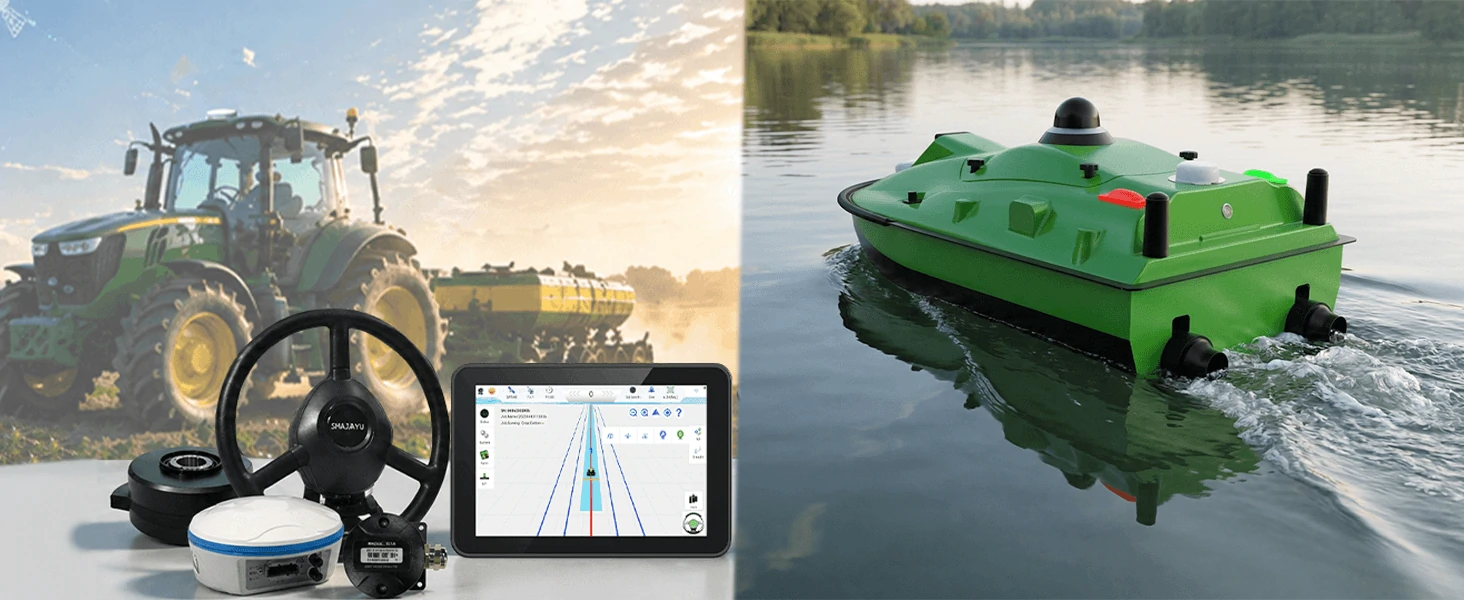
Traditional agricultural operations have long grappled with persistent pain points: low efficiency, significant resource waste, and inconsistent quality. SMAJAYU’s agricultural navigation system fundamentally transforms this landscape by leveraging RTK differential positioning technology to boost operational precision to within 2.5 centimeters.
Core Product: JY305 Tractor GPS Auto-Steering Navigation System
(1) Multi-Model Compatibility: Compatible with a wide range of agricultural machinery brands and types—including tractors, rice transplanters, crop protection vehicles, and harvesters.
(2) Comprehensive Scenario Coverage: Applicable across the entire operational lifecycle—encompassing tillage, transplanting, sowing, fertilizing, spraying, and harvesting.
(3) Intelligent Control: Features a built-in inertial navigation module that supports rapid calibration; paired with a visual display tablet, the operational trajectory is instantly clear at a glance.
Through automated steering, farmers can not only significantly reduce physical labor but also ensure consistent operational quality—ultimately maximizing crop yields and achieving a comprehensive enhancement of overall farm productivity.
In the fields of hydrological monitoring and emergency response, SMAJAYU has introduced the SMA iBoat-06 Unmanned Survey Vessel:
- Highly Integrated: Features a lightweight design that supports rapid deployment.
(2) Multi-Mission Capability: Suitable for a wide range of scenarios, including underwater terrain surveying, environmental monitoring, and emergency rescue operations.
(3) Unmanned Operation: Minimizes the risk of personnel exposure to water hazards while enhancing both the efficiency and safety of data acquisition.
- Why Choose SMAJAYU?
Comprehensive Product Portfolio: From agricultural autonomous driving to engineering surveying and hydrological monitoring, we offer a one-stop solution to meet the diverse needs of multiple industries.
Centimeter-Level Accuracy: Powered by RTK differential technology, we provide stable, reliable, and high-precision positioning services.
Proven User Satisfaction: Professional users across numerous countries and regions worldwide are currently utilizing SMAJAYU products to enhance their operational efficiency.
Open Ecosystem for Collaboration: SMAJAYU is actively recruiting distributors in various countries to collaborate with industry partners in building a robust network for precision services.
Conclusion
From vast agricultural fields to urban construction sites, and from mountainous surveying to aquatic monitoring, SMAJAYU remains steadfast in its philosophy of “Focus On Good,” leveraging technological innovation to drive industry advancement. Whether you are a farm owner seeking to reduce costs and boost efficiency, or a surveying engineer pursuing the utmost precision, SMAJAYU offers professional solutions tailored to your specific needs.
Are you ready to make your next project remarkably simple? Visit www.smajayu.com to learn more about our products, or contact us to become a regional distributor and join us in exploring the vast market of precision agriculture and intelligent surveying.
