

SMAJAYU Precision stands at the forefront of revolutionizing navigation through its high-precision and cost-effective RTK GNSS system. Specifically designed to elevate farming technology adoption across farms of all sizes, SMAJAYU's agriculture guidance and auto-steer solutions integrate GPS accuracy technology, guaranteeing centimeters of precision in farming operations. The company's innovative approach extends to its independently developed inertial navigation RTK receiver, equipped with a built-in Beidou/GNSS full-frequency antenna and supporting multiple frequencies. This introduction explores the pivotal role of navigation technology in contemporary agriculture and sets the stage for understanding the significance of GNSS RTK (Global Navigation Satellite System Real-Time Kinematic) technology in SMAJAYU Precision's transformative contributions.
Background
Navigation technology has undergone a fascinating evolution over centuries, from ancient methods relying on celestial cues and landmarks to the modern era's sophisticated systems. Early mariners navigated by the stars, and later, magnetic compasses revolutionized sea travel. Advancements in the 20th century brought radio navigation and radar, dramatically enhancing aviation and maritime operations.
Evolution of GNSS Technology
The Global Navigation Satellite System (GNSS) marks a significant leap forward in navigation. Originating with the launch of the first satellite, Sputnik, in 1957, the concept evolved with the U.S. Global Positioning System (GPS) becoming operational in the late 1970s. Over time, other nations introduced their GNSS constellations, such as Russia's GLONASS, the European Union's Galileo, and China's BeiDou. This collaboration resulted in a global network, providing users worldwide with precise positioning and timing information.
Despite historical advancements, traditional navigation systems faced inherent limitations. GPS signals struggled in urban canyons and dense foliage, leading to inaccuracies. Additionally, signal strength degradation due to atmospheric conditions and signal blockage posed challenges. These limitations hindered applications requiring high precision, such as agriculture, construction, and surveying.
GNSS RTK Technology
Definition and Explanation of GNSS RTK
GNSS Real-Time Kinematic (RTK) technology represents a breakthrough in overcoming the limitations of traditional navigation. RTK enhances the accuracy of positioning data in real time, providing centimeter-level precision. It leverages a network of GNSS satellites and a reference station to correct signal errors, ensuring precise location information for users.
How GNSS RTK Works
SMAJAYU Precision's contribution lies in its independently developed inertial navigation RTK receiver. This device integrates a built-in Beidou/GNSS full-frequency antenna, supporting multiple frequencies. The GNSS RTK system functions by comparing the signals received from satellites with those from a reference station. Real-time corrections are then applied to the user's position data, significantly improving accuracy.
The superiority of GNSS RTK technology becomes evident in its ability to provide centimeter-level accuracy in real-time. Unlike traditional systems, GNSS RTK minimizes errors caused by signal interference, atmospheric conditions, and other environmental factors. This precision is especially crucial in applications demanding accuracy, such as precision farming, construction site layout, and geodetic surveying.
Applications in Various Industries
SMAJAYU's GNSS RTK technology finds diverse applications across industries. In agriculture, it facilitates precision farming, optimizing crop yields by ensuring accurate placement of seeds and fertilizers. Construction benefits from precise site measurements, reducing errors in layout and improving overall project efficiency. Surveying professionals appreciate the technology's accuracy for mapping and geodetic purposes. The broad spectrum of applications underscores the versatility and transformative impact of GNSS RTK technology in enhancing navigation across multiple sectors.
SMAJAYU Precision's Contribution
Overview of SMAJAYU Precision
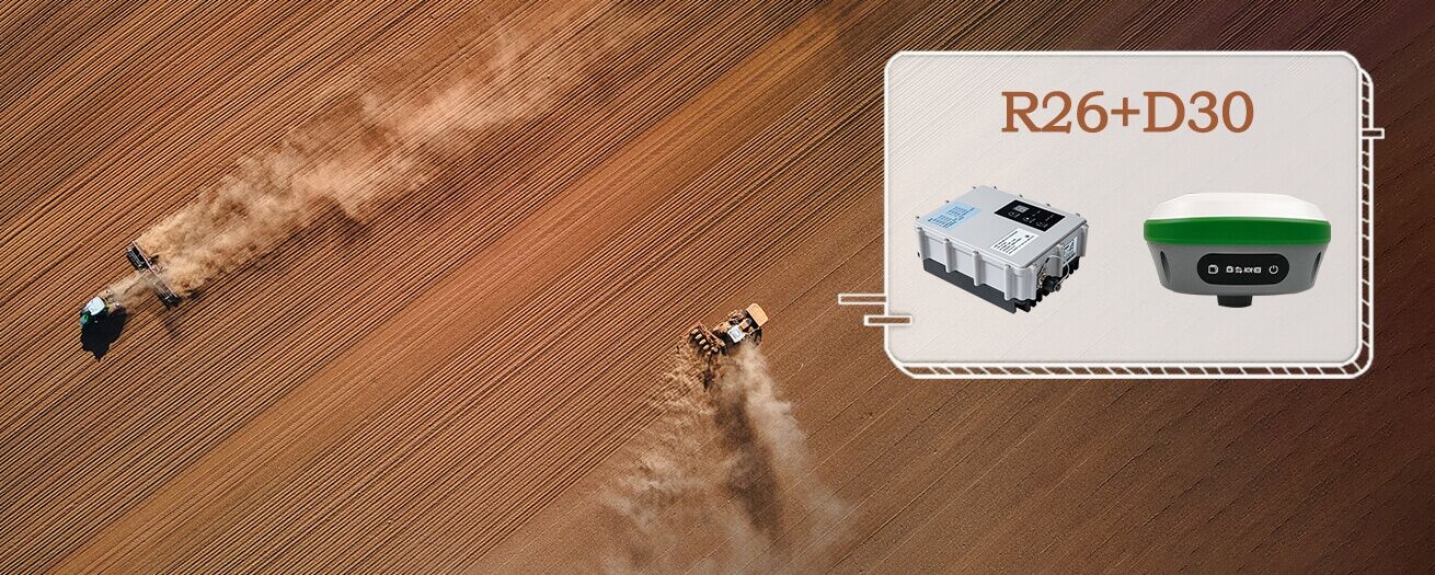
SMAJAYU Precision sets itself apart by offering a versatile GNSS RTK system that adapts seamlessly to various farm vehicles. This adaptability is achieved through the provision of variable accessories, ensuring compatibility with different vehicle standards. The user-friendly software interface enhances operational control during field activities. The inclusion of the R26 Surveying Base and D30 Radio Station, boasting a remarkable 20km signal range, further exemplifies SMAJAYU's commitment to providing comprehensive solutions.
Introduction to SMAJAYU's GNSS RTK Technology
Central to SMAJAYU's contribution is the R26 integrated Beidou/GNSS receiver. This device is equipped with a built-in large-capacity battery and a spacious memory card, ensuring sustained and efficient operation in the field. Its compatibility with various protocols, including SOUTH, TRIMTALK, and TRANSEOT(PCC), makes it versatile for applications in precision agriculture, surveying, geographic information systems, and Drone RTK communication. SMAJAYU's GNSS RTK technology emerges as a valuable tool for diverse sectors, addressing specific needs through its innovative features.
Key Features and Innovations
SMAJAYU's GNSS RTK technology stands out with key features such as the R26's integration of Beidou/GNSS, providing a reliable and accurate positioning system. The built-in large-capacity battery ensures extended field operations, while the inclusion of a high-capacity memory card facilitates data storage and retrieval. The D30 Radio Station's impressive 20km signal range enhances communication capabilities, establishing SMAJAYU as a leader in reliable and long-range GNSS RTK solutions.
Benefits of SMAJAYU's GNSS RTK Technology
Improved Accuracy and Precision
SMAJAYU Precision's GNSS RTK technology guarantees unparalleled accuracy, allowing users to achieve centimeter-level precision in their operations. This precision is crucial for tasks such as precise seed placement in agriculture and accurate layout in construction projects.
The advanced capabilities of SMAJAYU's GNSS RTK technology streamline navigation processes, reducing the margin for error and enhancing overall operational efficiency. Whether in the field or on a construction site, improved navigation accuracy leads to more efficient workflows.
Cost Savings for Businesses
The precision offered by SMAJAYU's GNSS RTK technology translates to optimized resource usage. In agriculture, for example, precise application of inputs reduces waste and contributes to cost savings. Similarly, in construction and surveying, accurate measurements minimize rework, saving both time and resources.
Positive Environmental Impact
By enabling precise operations, SMAJAYU's GNSS RTK technology contributes to environmentally sustainable practices. Reduced resource usage, minimized waste, and efficient navigation all play a role in promoting eco-friendly approaches across various industries. SMAJAYU's technology aligns with the growing importance of environmental considerations in modern business practices.
Industry Impact
Industries Benefiting from SMAJAYU's Technology
SMAJAYU's cutting-edge GNSS technology extends its impact across diverse industries. Precision agriculture experiences improved crop yield management, while construction benefits from accurate site layout and reduced rework. Surveying and geodetic applications achieve unprecedented accuracy, and the technology's adaptability positions it as a valuable asset in drone RTK communication.
Potential for Future Applications and Collaborations
SMAJAYU's commitment to innovation opens avenues for future applications and collaborations. The technology's versatility suggests potential expansion into emerging sectors and partnerships with other industry leaders. The forward-looking approach positions SMAJAYU as a catalyst for advancements, fostering a landscape where GNSS technology continues to redefine possibilities.
Challenges and Solutions
Common Challenges in GNSS Technology
The realm of GNSS technology faces challenges like signal interference, atmospheric conditions, and signal blockage. SMAJAYU acknowledges these industry-wide issues that can compromise accuracy, particularly in critical applications such as precision farming and construction.
SMAJAYU’s Solutions for Modern Challenges
SMAJAYU Precision tackles these challenges head-on through innovative solutions embedded in its GNSS technology. Advanced algorithms and signal processing techniques are employed to mitigate the impact of signal interference and atmospheric conditions, ensuring robust performance even in challenging environments. SMAJAYU's commitment to overcoming these hurdles sets its technology apart.
Continuous Improvement and Updates
Recognizing the dynamic nature of technology, SMAJAYU Precision prioritizes continuous improvement and updates. Regular firmware and software updates address evolving challenges and enhance the performance of their GNSS solutions. This dedication to staying at the forefront of technological advancements ensures that SMAJAYU's clients benefit from the latest innovations and improvements in the rapidly evolving field of GNSS technology.
In Closing
SMAJAYU stands as a beacon in revolutionizing navigation through its groundbreaking GNSS RTK technology. By seamlessly integrating high-precision solutions into diverse industries such as agriculture, construction, and surveying, SMAJAYU has redefined the standards of accuracy and efficiency. The adaptability of their technology, coupled with client success stories, underscores its transformative impact. As challenges are met with innovative solutions and a commitment to continuous improvement, SMAJAYU emerges as a driving force in shaping the future of navigation technology. In the era of GNSS RTK, SMAJAYU not only navigates the present but also charts a course for the evolving landscapes of precision and reliability.
