

High-accuracy GPS navigation plays a pivotal role in modern agriculture, revolutionizing traditional farming practices. This technology ensures precise operation line spacing and direction, reducing the demand for manual technical skills and significantly enhancing both accuracy and work efficiency. SMAJAYU, a cutting-edge guidance system, stands at the forefront of this agricultural innovation. By seamlessly integrating advanced GPS capabilities, SMAJAYU empowers farmers to navigate their tractors and equipment with unparalleled precision.
Traditional tractor navigation methods often rely on manual guidance, which can be imprecise and labor-intensive. Farmers face difficulties in maintaining consistent line spacing, resulting in uneven crop distribution and reduced yield. Additionally, the risk of overlap or missed areas during operations can lead to inefficient resource use and increased operational costs.
High-accuracy GPS navigation systems, such as SMAJAYU, offer a transformative solution to these challenges. They provide real-time, centimeter-level accuracy, enabling farmers to precisely control the path and spacing of their tractors and equipment. This accuracy minimizes overlap, reduces input wastage, and optimizes field coverage. As a result, farmers experience improved crop yield, resource management, and overall operational efficiency.
Impact on Productivity, Yield, and Resource Management
The adoption of high-accuracy GPS navigation technology in agriculture has far-reaching implications. It enhances productivity by reducing the time and effort required for manual navigation, allowing farmers to cover more ground in less time. Moreover, precise navigation results in uniform crop distribution, leading to increased yield and improved resource management as inputs such as seeds, fertilizers, and pesticides are used more efficiently. This not only benefits farmers’ bottom lines but also promotes sustainable farming practices.
Explanation of SMAJAYU JY100 Tractor GNSS Guidance System
SMAJAYU, represented by the JY100 guidance system, is an advanced GPS navigation solution tailored for precision agriculture. It comprises several key components, including a professional GNSS smart antenna, a large display, and intuitive guidance software. The software is designed with a farmer-friendly graphical user interface (GUI) featuring large, iconic buttons for easy operation. This user-centric design ensures that even with minimal training and guidance experience, farmers can quickly grasp the system’s functionalities.
The JY100 guidance system offers robustness, accuracy, and affordability, making it an ideal choice for a wide range of farming tasks. It enhances farm productivity by enabling precise navigation, extending operational hours, and optimizing various agricultural activities.
SMAJAYU leverages cutting-edge technology to significantly enhance GPS navigation accuracy. It utilizes a 10-inch waterproof tablet as part of its hardware setup, ensuring durability and usability in various environmental conditions. The system incorporates a high-precision GNSS antenna, allowing for centimeter-level positioning accuracy. SMAJAYU supports CORS (Continuously Operating Reference Stations) accounts, enabling users to access precision positioning data without the need for a separate base station. This streamlined approach reduces setup complexity and increases efficiency.
The system operates with a 2.5cm precision RTK (Real-Time Kinematic) guidance system, offering unparalleled accuracy during field operations. Job information is stored in the cloud, allowing for real-time monitoring and remote management of tasks, enhancing operational oversight and control. SMAJAYU’s robust design enables 24-hour continuous operation, eliminating concerns related to nighttime use. Its support for GNSS four-system full-band signals and strong anti-interference capabilities ensures reliable performance even in challenging operating environments. Overall, SMAJAYU’s technological advancements make it a reliable and precise GPS navigation solution for modern agriculture.
Hardware Requirements
- SMAJAYU T100 Control Tablet: The heart of the system, featuring a high-resolution 10.1-inch screen for user interface and control.
- 601A GNSS Antenna: A high-precision GNSS (Global Navigation Satellite System) antenna that ensures signal stability, minimizes interference, and contributes to precise positioning.
- Built-in High-Precision GNSS Board: The system incorporates a high-precision GNSS board, enhancing the accuracy of positioning and navigation.
- Easy and Fast Installation: SMAJAYU is designed for user-friendly installation, minimizing setup time and complexity.
Software Components and Platforms for SMAJAYU Integration
SMAJAYU’s software components are crucial for its functionality and integration into precision agriculture operations. While specific details may vary, key components often include:
- Guidance Software: The core of the system, providing the user interface, route planning, and guidance functionalities.
- Cloud Connectivity: Integration with cloud-based platforms for data storage, job monitoring, and remote management.
- Compatibility with Farm Management Software: Integration with farm management software allows seamless data exchange for planning and analysis.
- Real-Time Data Visualization: Tools and features for real-time visualization of field data, such as tractor position, task progress, and job status.
Accurate navigation with SMAJAYU relies on various data sources and inputs, including:
- Satellite Signals: Access to GNSS satellite signals, which are used for precise positioning and navigation.
- Base Station Data (CORS): If applicable, data from Continuously Operating Reference Stations (CORS) can be used to enhance precision.
- Terrain and Field Data: Geospatial information about the terrain and the field, which may include elevation, boundaries, and obstacles.
- Farm-Specific Data: Information specific to the farm, such as field boundaries, crop types, and task schedules, can be integrated for customized navigation plans.
- Weather Data: Real-time weather information may be incorporated to adjust navigation plans based on current conditions.
The seamless integration of these hardware and software components, along with access to accurate data sources, is essential for achieving high-accuracy tractor GPS navigation with SMAJAYU.
Data Management and Analysis
Collecting and Storing GPS Data for Future Analysis
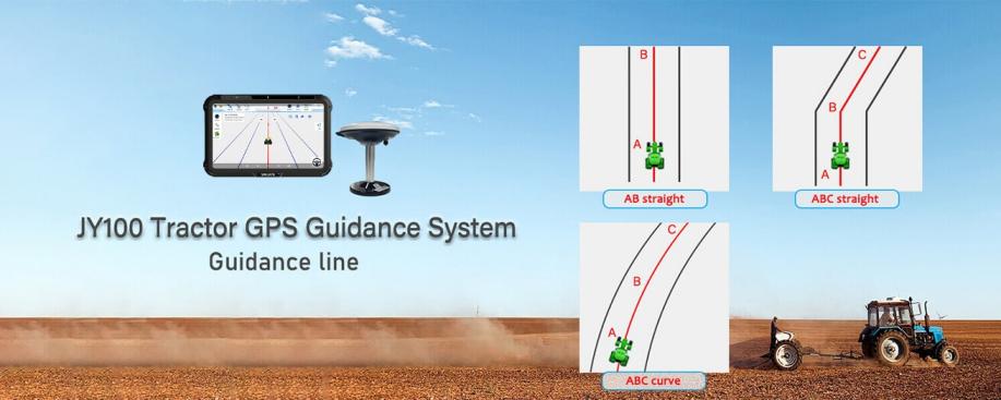
SMAJAYU captures a wealth of GPS data during tractor operations, including guidance lines (e.g., AB straight, ABC straight, ABC curve) and correction type (CORS-corrected at 2.5cm or non-corrected at 20-30cm). This data is systematically collected and stored, creating a valuable repository for future analysis and reference.
Analyzing GPS Data to Optimize Farming Practices
The collected GPS data serves as a foundation for in-depth analysis. Farmers and agricultural experts can leverage this data to evaluate the efficiency of past operations, identify areas for improvement, and make data-driven decisions to optimize farming practices. Analysis can include assessing the accuracy of navigation, identifying patterns, and determining resource utilization.
Reporting and Visualization Tools for Better Decision-making
SMAJAYU often provides reporting and visualization tools that enable users to interpret GPS data effectively. These tools offer graphical representations, charts, and reports that facilitate decision-making. Farmers can gain insights into field performance, crop health, and operational efficiency, ultimately leading to informed decisions that enhance agricultural productivity and sustainability.
Challenges and Considerations
Cost: High-accuracy GPS systems can be relatively expensive, posing a financial barrier to some farmers.
Infrastructure: Adequate infrastructure, including base stations and CORS, may not be available in all regions.
Learning Curve: Farmers and operators may require training to effectively use and benefit from these systems.
Signal Interference: Environmental factors, structures, or topography can disrupt GPS signals, affecting accuracy.
Environmental Factors Affecting GPS Accuracy
- Tree Canopy and Obstacles: Dense tree cover and tall structures can obstruct GPS signals, leading to accuracy issues in certain areas.
- Atmospheric Conditions: Changes in atmospheric conditions, such as ionospheric disturbances, can affect signal propagation and accuracy.
- Signal Multipath: Signal reflections off surfaces can cause signal interference, leading to inaccurate readings.
- Terrain: Hilly or uneven terrain can impact signal reception, especially in valleys or areas with limited line-of-sight to satellites.
Maintenance and Ongoing Support Requirements
- System Updates: Regular software and firmware updates are essential to ensure optimal system performance.
- Calibration: Periodic calibration of GPS equipment may be necessary to maintain accuracy.
- Technical Support: Access to technical support and service providers is crucial for troubleshooting and addressing issues promptly.
- Data Management: Efficient data management and storage practices are needed to handle the large volume of GPS data generated.
Future Developments and Trends
- Advanced Sensors: Integration of more sensors, such as LiDAR and multispectral cameras, for enhanced data collection.
- Satellite Systems: Leveraging emerging satellite systems like Galileo and BeiDou to improve global positioning accuracy.
- IoT Integration: Greater integration with the Internet of Things (IoT) for real-time data sharing and decision support.
How SMAJAYU or Similar Systems Might Evolve
- Enhanced Precision: Continued refinement of hardware and software components for even higher accuracy.
- Accessibility: Efforts to make high-accuracy GPS systems more affordable and accessible to a broader range of farmers.
- Integration: Closer integration with other agricultural machinery and systems for seamless operations.
The role of AI and Machine Learning in Enhancing Accuracy
- AI-Driven Algorithms: Adoption of AI and machine learning algorithms to improve data analysis and correction methods.
- Predictive Analytics: Using AI to predict optimal planting, irrigation, and harvesting times based on historical and real-time data.
- Autonomous Farming: Advancements in AI-powered autonomous farming, reducing the need for manual intervention in navigation and operations.
Embrace Precision Farming for a Prosperous Agricultural Future
To sum up, the adoption of high-accuracy tractor GPS navigation, exemplified by SMAJAYU, marks a significant advancement in contemporary agriculture. By surmounting obstacles, it delivers precision, efficiency, and data-driven insights that enable farmers to refine their methods and boost productivity. With ongoing technological progress, SMAJAYU and comparable systems are primed to be key players in the sustainable, data-driven evolution of farming, propelling agricultural prosperity and securing abundant harvests in the years ahead.
