

SMAJAYU’s Smart GNSS Land Leveling System, embodied in the advanced JYL20 system, revolutionizes agricultural practices. Comprising a control table, high precision controller, HD camera, A10 GNSS antenna, and specialized GNSS Land Leveling software, this system epitomizes cutting-edge technology in farming. Precision is paramount in land leveling, and the JYL20 system ensures optimal accuracy through its integrated components. The significance lies in enhancing efficiency, reducing resource wastage, and optimizing crop yield. As agriculture embraces innovation, SMAJAYU’s Smart GNSS System emerges as a crucial tool for farmers seeking precision and productivity in their land management practices.
System Components
The JYL20 GNSS land leveling system represents state-of-the-art technology tailored for precise and accurate land leveling. Its design incorporates essential components, each pivotal in achieving optimal performance and operational efficiency.
GNSS Technology
Global Navigation Satellite System (GNSS) Explanation: GNSS, a satellite-based navigation system offering global geolocation and time information, utilizes constellations of satellites transmitting signals. This capability allows the JYL20 system to precisely determine its Earth’s surface position.
Precision Land Leveling Role of GNSS: GNSS is central to achieving precision in land leveling by furnishing real-time and accurate positioning data to the system. This empowers the JYL20 system to accurately guide and control leveling machinery, ensuring precise leveling operations.
Smart Sensors
System’s Sensor Overview: Equipped with advanced smart sensors, including accelerometers, gyroscopes, and environmental sensors, the JYL20 system captures and processes real-time data during land leveling operations. This comprehensive sensor suite enhances the system’s understanding of working conditions.
Contribution of Sensors to Precision: Smart sensors play a significant role in precision by continuously monitoring equipment movements, terrain conditions, and other relevant parameters. This real-time data processing allows the system to make instantaneous adjustments, maintaining optimal leveling accuracy.
Machinery Integration
Compatibility with Existing Equipment: Designed for seamless integration with various land-leveling equipment such as shovels, scrapers, bulldozers, and graders, the JYL20 system ensures compatibility. This design allows operators to adapt their current machinery, benefiting from the precision and efficiency of the JYL20 system.
Efficient Operation Through Seamless Integration: Integrating the JYL20 system with land-leveling machinery is smooth and efficient. This feature enables operators to transition easily to this advanced technology, contributing to improved operational efficiency and facilitating precise and fatigue-reducing land leveling operations.
Key Features
Real-time Data Acquisition
Significance of Real-time Information in Land Leveling: Immediate and accurate land-level decision-making relies on real-time data. The JYL20 system utilizes real-time information to elevate precision and efficiency during leveling operations.
Dynamic Data Acquisition and Processing: The system acquires data on the fly by continuously monitoring and collecting information during land leveling. This real-time data undergoes instant processing, enabling the system to adjust quickly for optimal performance.
Automated Control
Overview of Automated Control Mechanisms: Featuring automated control mechanisms, the JYL20 system can autonomously identify terrain and adjust the plot datum. This capability contributes to a remarkable 20% improvement in operational efficiency.
Reduced Human Intervention for Enhanced Efficiency: The system significantly diminishes the need for human intervention, functioning efficiently in diverse conditions such as day, night, wind, dust, and haze. This automation enhances efficiency by minimizing reliance on manual adjustments.
Precision Mapping
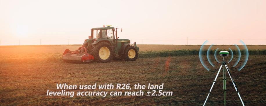
Mapping Expertise for Accurate Land Leveling: The JYL20 system excels in precision mapping, achieving land leveling accuracy within ±2.5cm. This remarkable precision ensures that land is leveled precisely as required, meeting specified standards.
Visual Representation of Land Features for Informed Decision-making: The system visually represents land features, assisting operators in making informed decisions. This visualization capability enhances overall terrain understanding, facilitating optimal decision-making for land leveling outcomes.
Benefits
Increased Efficiency
Enhanced Operational Efficiency: The JYL20 system provides an operation track, and high and low terrain map in an intuitive format, resulting in a 30% increase in leveling efficiency. This translates to reduced time and resources, offering improved productivity for farmers.
Cost Savings
Economic Benefits for Users: Users of the JYL20 system experience economic benefits through reduced operational costs and increased efficiency. The system’s cost-effective operation contributes to overall financial gains for users.
Environmental Impact
Promoting Sustainable Farming Practices: The JYL20 system encourages sustainable farming practices by optimizing land leveling processes. This not only improves efficiency but also aligns with environmentally conscious agricultural practices.
Reduced Ecological Footprint: By minimizing the need for additional resources and promoting efficient land leveling, the system contributes to a reduced ecological footprint. This aligns with environmental conservation efforts and sustainable land management practices.
Use Cases
Farms Implementing the Smart GNSS Land Leveling System
The Smart GNSS Land Leveling System has succeeded across diverse applications, including tractors, harvesting machines, plant protection machinery, rice transplants, and other agricultural vehicles. Its versatility makes it suitable for various work scenarios such as sowing, cultivating, trenching, ridging, pesticide spraying, transplanting, land consolidation, and harvesting. Farms implementing this system have reported notable operational efficiency and precision improvements across various agricultural activities.
Quantifiable Improvements in Yield and Resource Utilization
Implementing the Smart GNSS Land Leveling System has resulted in quantifiable improvements in yield and resource utilization. Farmers using this advanced technology have witnessed increased crop yields due to precise land leveling, optimal soil conditions, and efficient use of resources. The system’s ability to minimize input wastage and enhance operational efficiency contributes to improved agricultural productivity. This showcases the tangible and measurable benefits of adopting the Smart GNSS Land Leveling System in optimizing agricultural practices and maximizing overall yield.
Challenges and Solutions
Potential Hurdles in Implementing Precision Land Leveling
Implementing precision land leveling may encounter obstacles such as adapting to diverse terrains, handling varying weather conditions, and seamlessly integrating with existing equipment. These challenges have the potential to impede the effective deployment of the technology, necessitating careful consideration and strategic solutions.
SMAJAYU’s System: Addressing Challenges with Adaptability
SMAJAYU’s system effectively tackles these challenges by providing adaptable technology that integrates with various land-leveling equipment. With advanced features like automated control mechanisms and real-time data acquisition, the system can navigate diverse terrains and operate efficiently under different weather conditions. This adaptability ensures the resilience and effectiveness of precision land leveling technology, offering a comprehensive solution to challenges encountered during implementation. In summary, SMAJAYU’s system presents a tailored solution to enhance the precision and efficiency of land leveling operations, effectively mitigating potential challenges.
Future Advancements
Ongoing System Enhancement and Updates
SMAJAYU envisions continual progress in its land leveling system, emphasizing continuous refinement and regular updates. The company remains dedicated to improving and enriching the system’s capabilities to align with the dynamic requirements of modern agriculture. This steadfast commitment to enhancement ensures users access the latest technologies and functionalities for precision land leveling.
Integration with Emerging Technological Trends
The future promises exciting prospects as SMAJAYU strives to integrate its land leveling system with emerging technologies. This involves exploring synergies with artificial intelligence, machine learning, and other forefront innovations. By remaining at the forefront of technological progress, SMAJAYU aims to deliver a seamlessly integrated, state-of-the-art solution that maximizes the potential of emerging technologies within the agricultural landscape.
In Closing
JYL20 GNSS land leveling system by SMAJAYU stands as an innovative and adaptable solution for precision agriculture. With its advanced features, including real-time data acquisition, automated control, and precision mapping, the system addresses the complexities of land leveling with efficiency and accuracy. Success stories from farms implementing this technology showcase its versatility across various agricultural applications, leading to quantifiable yield and resource utilization improvements. SMAJAYU’s commitment to continuous improvement and integration with emerging technologies positions the system at the forefront of precision farming, promising sustained advancements and enhanced capabilities. As agriculture evolves, the JYL20 system remains a pivotal tool, contributing to increased efficiency, cost savings, and environmentally conscious farming practices.
