

The use of Land Surveying GPS Tools revolutionized the way land surveys are conducted. In the past, land surveys were conducted using conventional methods such as ground-based trilateration. This process was time-consuming and often inaccurate. GPS tools have made land surveying much more efficient.
GPS land surveying system
GPS land surveying system is a surveying technology that uses the Global Positioning System (GPS) to measure points on the earth’s surface. It is a relatively new technology that is becoming increasingly popular, especially in large-scale surveying projects. GPS surveying is often used in construction, engineering, and land management projects. A GPS land surveying system can save you time, money, and headaches
Land surveying GPS tools are a great way to get an accurate reading of your property boundaries. There are many different types of GPS devices on the market, but they all serve the same purpose: to help you determine the precise location of your property boundaries.
GPS surveying tools have been used for a variety of surveying applications since the early 1990s. GPS tools offer many advantages over traditional surveying methods, including greater accuracy, faster data collection, and the ability to survey in difficult-to-reach areas.
Why GPS Tools is Essential for Land Surveying?
Land surveying is the art, profession, and science of finding the position of objects on the ground or in three dimensions, as well as the distances and angles between them. Land surveyors are qualified individuals who conduct land surveys. While GPS technology has been around for a while, it is only recently that GPS tools have become essential for land surveying. GPS tools allow surveyors to map the land, more and to do so in a shorter amount of time. GPS tools can also be used to map the land in three dimensions, which is essential for land surveying.
They provide an efficient and accurate way to collect data. They can be used to measure distance, calculate area, and create maps. GPS tools can also be used to locate property boundaries, mark corners, and set stakes.
3 Types of Land Surveying GPS Tools You Need to Know About
There are three main types of GPS tools used for land surveying: hand-held, GPS receiver, and GPS antenna. Each has its advantages and disadvantages, so it’s important to choose the right one for your project. Below is a description of each category.
- Handheld GPS tool
A handheld GPS unit is a GPS device that is small enough to be carried in your hand. It usually has a built-in antenna and runs on batteries. A handheld GPS unit is very useful for land surveying because it can be used to take accurate measurements of distances, directions, and positions without having to set up a base station. There are many benefits of using a handheld GPS unit when surveying land. GPS units allow surveyors to work more efficiently and accurately. They also provide surveyors with the ability to store data and share it with others.
- GPS receiver
A GPS receiver is a device used to receive signals from GPS satellites and determine the user’s location. GPS receivers come in a variety of shapes and sizes, from handheld units to vehicle-mounted units to surveying-grade units. GPS receivers are used in a variety of applications, including navigation, mapping, surveying, and precision agriculture. A GPS Receiver is a great tool for any surveyor. It can help you determine the accurate location of your survey points and make sure that your measurements are accurate. It can also be used to find your way back to your starting point if you get lost in the field.
- GPS antenna
If you’re a land surveyor, then you know that having a reliable and accurate GPS antenna is essential to your work. A GPS antenna is a device that helps to amplify the signal from the GPS satellite so that it can be more accurately received by the GPS receiver. It is important to have a good quality GPS antenna to get the most accurate readings from your GPS device. There are many different types of GPS antennas, and they vary in size, shape, and price. GPS antennas are not just for surveyors, however; they can also be used for navigation, mapping, and even tracking.
The Benefits of Land Surveying GPS Tools
The use of GPS tools in land surveying can provide many benefits, including more accurate measurements, faster surveys, and the ability to survey in difficult-to-reach areas. In the past, surveyors had to rely on more primitive methods, such as theodolites, to take measurements. GPS surveying tools have made the process of surveying much faster and more accurate. GPS tools can also be used to create 3D models of the land, which can be helpful in planning and development. GPS-based surveying systems can help surveyors to avoid potential hazards and work more efficiently in adverse weather conditions
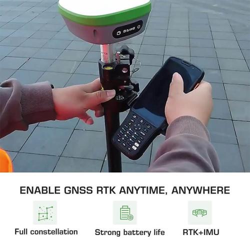
GNSS Surveying System by SMAJAYU for land surveying
If you’re looking for the best GPS tools for your land surveying needs, look no further than the SMAJAYU Land Surveying system. This system uses a GPS and a computer to calculate the measurements of your land. With SMAJAYU, you can quickly and easily survey your land without worrying about the accuracy of your measurements. The system consists of a power cable, power adapter, nine-core setting line, hand-held charger, hand-held adapter, handheld bracket, and GNSS Receiver.
Conclusion
In nutshell, it is not wrong to say that GPS tools are becoming increasingly popular for land surveying due to their accuracy and efficiency. They help you determine the precise location of your property boundaries. Without them, your survey could be inaccurate. Get your top-notch quality GNSS Surveying system from us today.
