

- As they simplify managing a farm, farm GPS navigation system is growing in popularity among farmers. GPS devices may assist farmers with route planning, equipment tracking, and crop and soil condition monitoring. The optimal times to plant and harvest crops may be determined using GPS devices, which can also be used to watch weather trends and observe animal movements.
- Specifically created for agriculture, a farm GPS navigation system is a kind of GPS (Global Positioning System) technology. It helps farmers better manage their operations by giving them accurate location information for their farm machinery.
- The system, which is often made up of GPS receivers, display devices, and mapping software, gives real-time information on the location and movement of farm equipment and the locations of crops, fields, and other significant elements on the farm.
- To offer a thorough picture of farm operations and aid farmers in making better-informed decisions, the system may also be combined with other farm management technologies, including yield monitoring systems, variable-rate application systems, and soil sensors.
For a good reason, GPS navigation devices are increasingly used in farming. These technologies are an excellent method to boost productivity and maximize efficiency. Farmers can precisely plan routes, track assets, keep an eye on crops, manage fleets, and improve safety thanks to GPS technology. By giving them precise, up-to-date information about their agricultural activities, GPS navigation devices may help farmers increase efficiency. This knowledge can be applied to:
- Improved field mapping and management:
Improved field mapping and management are possible because GPS navigation devices may deliver comprehensive maps of agricultural fields showing crop borders and other characteristics. Farmers that use this information may more effectively plan their operations and enhance their crop management techniques.
- Optimize equipment use:
The location and movement of agricultural equipment may be tracked in real-time using GPS navigation systems, allowing farmers to prevent overlapping and repeating labour. Farmers may be able to do this to save time, resources, and gasoline.
- Improve precision agriculture:
To increase precision agriculture, GPS navigation systems may be combined with other farm management instruments, such as yield monitoring systems, soil sensors, and variable-rate application systems. To assist farmers in making better-informed decisions and improving their agricultural practices, this integration may give them a full perspective of their farm operations, including crop and soil health.
- Improve agricultural yield:
By using a farm GPS navigation system to apply fertilizer and other inputs at the appropriate time and in the right amount using accurate position data, farmers may increase crop yields. GPS navigation devices may aid farmers in streamlining their processes, boosting production, and enhancing their crops’ general well-being and yield.
- Enhanced safety:
GPS systems may assist in making sure that machinery and vehicles are moved safely and effectively on farms, lowering the chance of accidents and property damage.
- Improved record keeping:
GPS devices may gather the information that can be used to monitor agricultural activities and enhance record keeping, assisting farmers in making future choices.
Several factors make the use of GPS navigation systems in farming crucial, including:
- Increasing productivity:
By automating processes, boosting effectiveness, and reducing the need for manual labour, GPS systems free up farmers’ time to work on other crucial activities.
- Increasing profitability:
Farmers may boost their overall profitability by lowering operating expenses, raising yields, and improving resource management.
- Accurate mapping and data collection:
GPS navigation systems enable farmers to map and monitor their fields with precision, collect data, and make decisions about planting, fertilizing, and harvesting crops that are well-informed.
- Sustainability:
GPS systems can help ensure the long-term viability of agricultural methods by lowering waste, boosting yields, and enhancing resource management. This farming system may result in a more effective, lucrative, and productive business while also assisting in maintaining sustainability and safety.
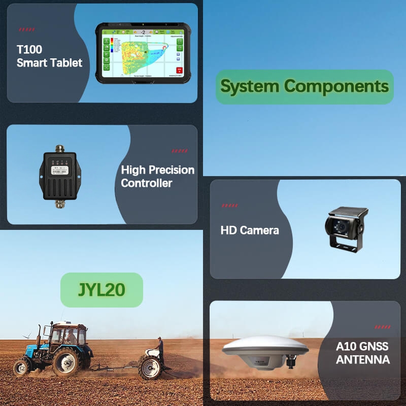
Farmers can easily traverse their fields, track their cars and equipment, and make data-driven choices about planting, fertilizing, and harvesting crops thanks to a farm GPS navigation system. Farmers may increase their productivity and profitability by automating operations, minimizing manual labour, and enhancing resource management. The following elements are frequently found in the mechanism of a farm GPS navigation system:
- GPS receiver:
Used to track the location of a vehicle or piece of equipment and give navigational assistance, a GPS receiver receives signals from GPS satellites. The navigational information and maps are displayed on a device such as a tablet or a screen.
- Software for mapping:
Mapping software is used to show maps, aerial photography, and other data, such as information on crop types, field borders, and soil types.
- Control unit for the vehicle or equipment:
Based on the navigational data obtained from the GPS receiver, the control unit, which is normally installed on the vehicle or equipment, is used to control the movement of the vehicle or equipment.
- Data collection and storage:
GPS systems can gather and store data, including information about crop types, soil types, and field borders.
Conclusion:
Farm GPS navigation system is expanding because they provide farmers with numerous benefits in terms of precision, accuracy, and efficiency. These systems guide tractors and other farm machinery automatically using GPS technology, doing away with the need for manual labor. The SMAJAYU produces products that are designed to make your life easier. If you have a flat tyre or need to replace a tyre, this technology is designed to drive your automobile for you. Additionally, it is designed to make parking your automobile in restricted spaces simpler. It may be used with various agricultural tools and GPS to steer the vehicle in a certain direction. Its goal is to increase agricultural output and minimize operator fatigue.
