

SMAJAYU’s Bulldozer GNSS Navigation is a cutting-edge guidance system that revolutionizes earthmoving operations. This innovative technology ensures precise operation line spacing and direction, significantly reducing the need for manual technical expertise. Precision in earthmoving is paramount as it minimizes errors, enhances work efficiency, and reduces costs. Accurate earthmoving not only saves time but also minimizes environmental impact and improves safety on construction sites.
Understanding GNSS Technology
GNSS Technology Unveiled
GNSS, an acronym for the Global Navigation Satellite System, comprises a constellation of satellites orbiting our planet. These orbiters broadcast signals, which ground-based GNSS receivers capture. Through the meticulous calculation of signal travel times from multiple satellites to the receiver, GNSS can precisely ascertain the receiver’s location, speed, and even the current time. Prominent GNSS systems include the familiar GPS (Global Positioning System), GLONASS, Galileo, and BeiDou. These systems offer worldwide coverage and serve as foundational tools in diverse domains, such as navigation, surveying, and construction.
GNSS’s Crucial Role in Construction and Earthmoving
Within the construction and earthmoving domains, GNSS technology assumes a pivotal role in ensuring the precise positioning and navigation of heavy machinery, including bulldozers. By outfitting these machines with GNSS receivers and antennas, construction experts can continuously monitor their precise whereabouts in real-time. This valuable data empowers operators to adhere to predefined routes, achieve meticulous grade control, and circumvent obstacles. The end result is enhanced efficiency and the delivery of earthmoving operations with heightened accuracy.
GNSS technology brings forth a multitude of advantages in the realm of bulldozer navigation:
- Precision: GNSS provides a level of accuracy that reaches sub-centimeter levels, ensuring that bulldozers can meticulously follow designated paths and grade specifications.
- Efficiency: It mitigates the necessity for labor-intensive manual surveying and stakeout procedures, leading to time and cost savings.
- Safety: The heightened precision reduces the likelihood of accidents and collisions on construction sites, enhancing overall safety.
- Cost-Efficiency: Enhanced precision minimizes the occurrence of material overruns and the need for costly rework, ultimately resulting in cost savings for construction projects.
- Environmental Stewardship: Accurate earthmoving practices curtail environmental disruption and the wastage of valuable resources, aligning with sustainability objectives in construction.
SMAJAYU’s JY100 guidance system is a cutting-edge solution designed to elevate precision in earthmoving and construction operations. Comprising a professional GNSS smart antenna, a large display, and intuitive guidance software, this system caters to the needs of modern precision-oriented professionals. The user-friendly graphical user interface (GUI) with large, easily recognizable buttons ensures that even with minimal training and guidance experience, operators can quickly become proficient.
The JY100 system is characterized by its robustness, accuracy, and affordability, making it a versatile tool for various farming and earthmoving tasks. It extends operational hours and enhances overall productivity on construction and agricultural sites.
Key Features and Components
10-inch Waterproof Tablet: The system is equipped with a 10-inch waterproof tablet, providing a clear and durable interface for operators to interact with.
- High Precision GNSS Antenna: SMAJAYU’s GNSS antenna is designed for high precision, enabling sub-centimeter-level accuracy when coupled with correction services.
- Portability and Easy Installation: The system is highly portable and straightforward to install on bulldozers, ensuring minimal downtime during implementation.
- Support for CORS (Continuously Operating Reference Stations) Accounts: CORS accounts offer access to precision correction data, further enhancing the accuracy of the system’s positioning.
How SMAJAYU’s System Enhances Precision
SMAJAYU’s Bulldozer GNSS Navigation System employs several strategies to enhance precision:
- Guidance Line Options: The system offers various guidance line options, including AB straight, ABC straight, and ABC curve, enabling operators to choose the most suitable path for their specific earthmoving requirements.
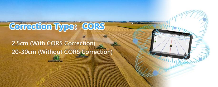
- Correction Type: CORS: Utilizing CORS correction data, the system achieves remarkable precision, with positioning accuracy reaching 2.5cm. This level of accuracy is crucial for maintaining precise grade control and executing earthmoving tasks with meticulousness.
- Accuracy Without Correction: Even without CORS correction, the system maintains a commendable accuracy level, typically within the range of 20-30cm. While not as precise as with CORS, this accuracy is still valuable for many construction and earthmoving applications.
SMAJAYU’s Bulldozer GNSS Navigation achieves precision through a combination of cutting-edge technology and advanced algorithms:
- High-Precision Positioning Board: The system employs a high-precision positioning board that eliminates the need to connect to a base station, ensuring maximum centimeter-level positioning accuracy. This feature streamlines setup and operation while delivering remarkable precision.
- 2.5cm Precision RTK Guidance System: SMAJAYU’s system utilizes Real-Time Kinematic (RTK) technology, providing exceptional positioning accuracy down to 2.5 centimeters. RTK is renowned for its ability to deliver real-time, sub-centimeter-level precision.
- Cloud Storage of Job Information: Job information is stored in the cloud, enabling real-time access and job status monitoring from a remote location. This facilitates efficient and effective remote management of earthmoving operations.
- Continuous 24-hour Operation: The system is designed to operate continuously for 24 hours, ensuring uninterrupted functionality even during night-time operations when vision may be impaired. This reliability eliminates downtime due to night vision limitations.
- Support for GNSS Four-System Full-Band Signal: By supporting GNSS signals from all four major global navigation satellite systems (GPS, GLONASS, Galileo, and BeiDou), the system maximizes positioning accuracy and availability.
- Strong Anti-Interference Capability: SMAJAYU’s Bulldozer GNSS Navigation is engineered to withstand the harshest operating environments thanks to its robust anti-interference capabilities. This ensures consistent and reliable performance even in challenging conditions.
Real-Time Data Processing and Feedback
SMAJAYU’s system excels in real-time data processing, swiftly analyzing information from multiple satellites and sensors to provide instant feedback to operators. Real-time data processing allows for immediate course corrections and adjustments, ensuring that earthmoving tasks adhere to precise specifications. The system’s ability to provide instantaneous feedback enhances operator confidence and contributes to the overall precision of the operation.
Types of Construction Projects where the System is Applicable
SMAJAYU’s Bulldozer GNSS Navigation has a wide range of applications in various construction projects, including:
- Road Construction: It ensures precise grading and leveling for road construction, resulting in smoother surfaces and improved safety.
- Building Construction: The system aids in foundation excavation and site preparation, ensuring accuracy in structural elements.
- Land Development: It helps in land clearing, grading, and shaping for residential and commercial developments.
- Infrastructure Projects: The system contributes to the construction of bridges, dams, airports, and other large-scale infrastructure projects.
- Mining Operations: It enhances precision in excavation and resource extraction in the mining industry.
Industry Sectors Benefiting from the Technology
SMAJAYU’s system finds applications beyond construction in sectors such as:
- Agriculture: It assists in precision agriculture by optimizing land preparation and field leveling.
- Mining: The system aids in precise excavation and haul road construction in mining operations.
- Forestry: It contributes to forest road construction and terrain modification for sustainable forestry practices.
- Environmental Restoration: The technology facilitates accurate grading for habitat restoration projects.
- Utilities: It assists in trenching and excavation for utility line installations.
Potential Future Applications
The versatility and precision of SMAJAYU’s Bulldozer GNSS Navigation open the door to future applications, including:
- Autonomous Operation: Integration with autonomous systems for unmanned earthmoving operations.
- Smart Cities: Enabling precise construction for urban development and infrastructure in smart city projects.
- Disaster Response: Rapid terrain modification for disaster response and recovery efforts.Underwater Construction: Adapting the technology for precise underwater construction and dredging.
- Space Exploration: Potential applications in lunar or Martian surface construction for space exploration missions.
SMAJAYU’s Bulldozer GNSS Navigation stands as a groundbreaking achievement in precision earthmoving technology. Its exceptional precision in positioning, real-time data processing capabilities, and adaptability extend well beyond construction, fostering both safety and environmental responsibility. The system’s capacity to attain sub-centimeter accuracy across diverse construction projects and industries highlights its pivotal role in contemporary construction and land development. As technology progresses, SMAJAYU’s innovation paves a promising path for the future of precision earthmoving.
